Historical Photo - Albums
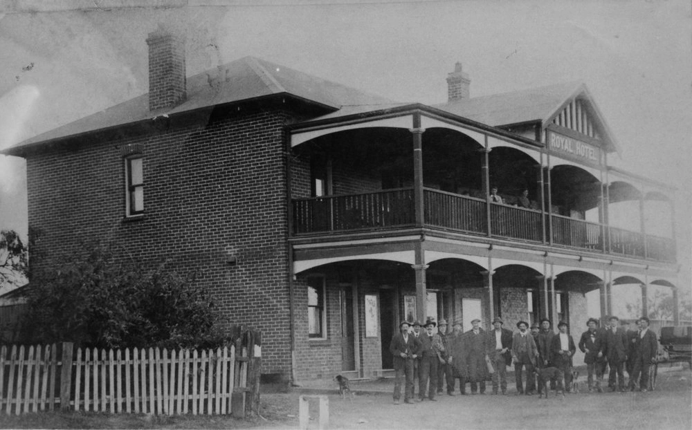
Royal Hotel
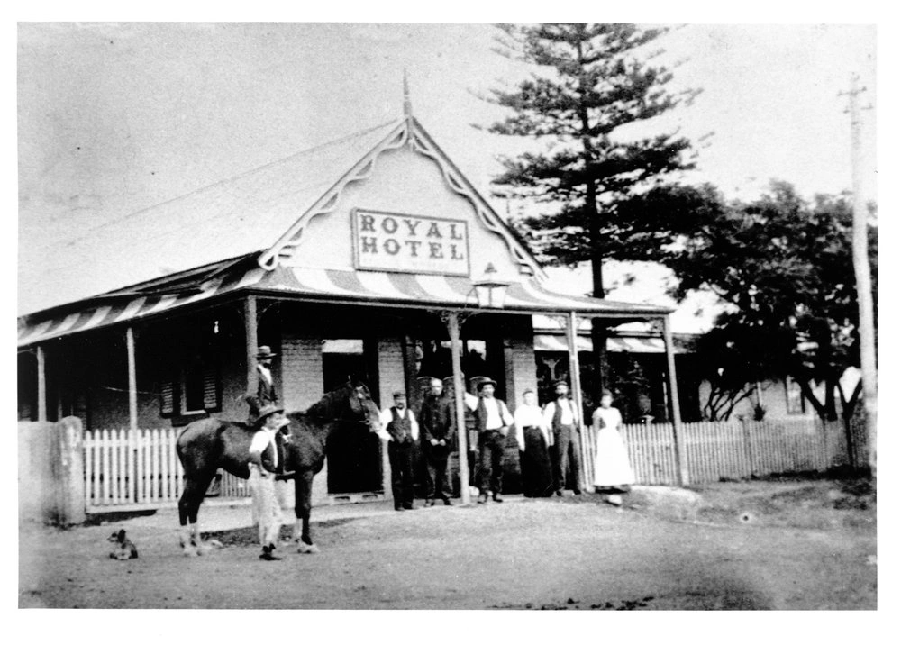
The first Royal Hotel, built on the northern side of the railway line, near the current transport interchange, was demolished in May 1914. The 'new' Royal Hotel was built on the southern side of the railway station in Main Street in 1914. The hotel was demolished in 1937 and was replaced by the Robin Hood Inn.
The second Royal Hotel to be built in Blacktown. It was located opposite the railway station, on the southern side of Blacktown Road (later known as Main Street). It was demolished during 1936-37 and replaced by the Robin Hood Inn.
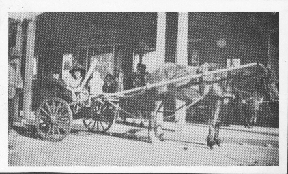
Horse and cart outside Royal Hotel on Main Street. This Royal Hotel was built in 1914 and was replaced by Robin Hood Inn which was demolished in 1984.
The first Royal Hotel, built on the northern side of the railway line, near the current transport interchange, was demolished in May 1914. The 'new' Royal Hotel was built on the southern side of the railway station in Main Street in 1914. The hotel was demolished in 1937 and was replaced by the Robin Hood Inn.
The second Royal Hotel to be built in Blacktown. It was located opposite the railway station, on the southern side of Blacktown Road (later known as Main Street). It was demolished during 1936-37 and replaced by the Robin Hood Inn.
Horse and cart outside Royal Hotel on Main Street. This Royal Hotel was built in 1914 and was replaced by Robin Hood Inn which was demolished in 1984.
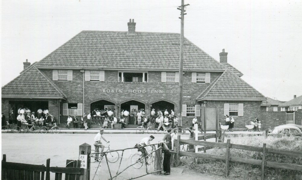
Robin Hood Inn
Robin Hood Inn situated in Main Street (previously Blacktown Road), Blacktown. It was demolished in 1984.
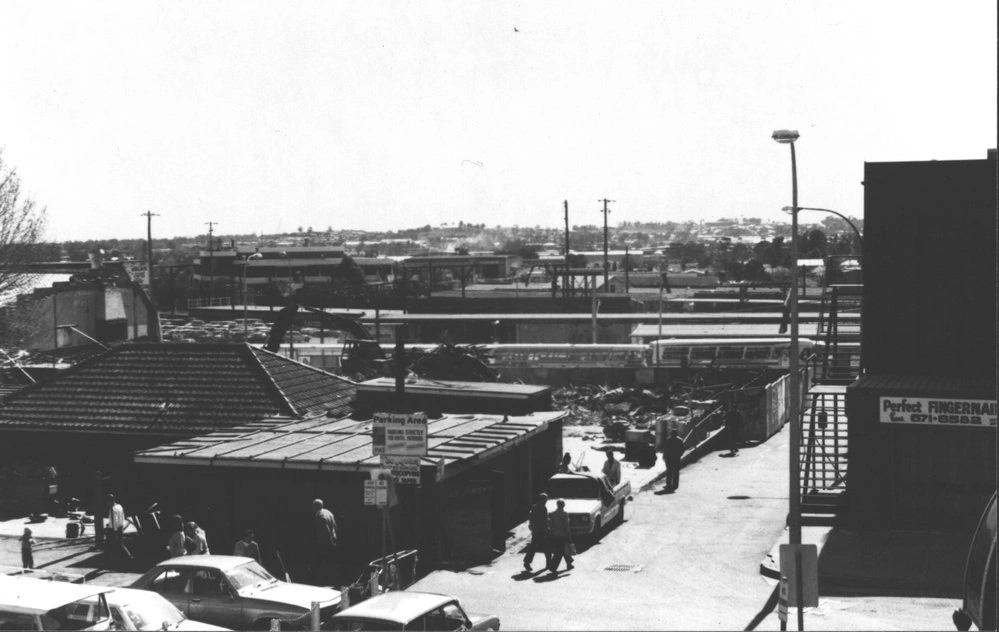
The Robin Hood Inn was demolished overnight on August 12 1984. The hotel faced Main Street and was opposite the railway station. This photo is taken looking north (from the back of the hotel). The lounge and garden areas are still visible. The laneway on the right of the photograph is now called the Jim Simpson Laneway.
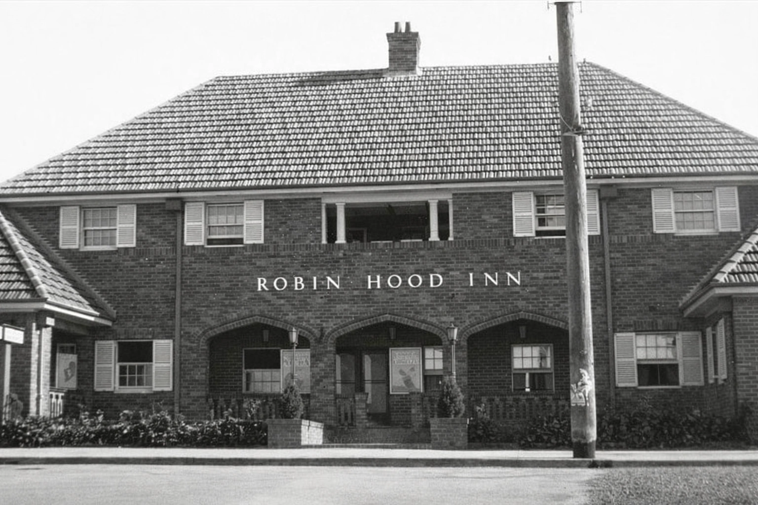
The Robin Hood Inn replaced the Royal Hotel, and was built in 1936 - 1937. It was situated in Main Street (previously Blacktown Road), Blacktown, near the railway station. The Robin Hood Inn was demolished in 1984. The site today (2013) is the location of the multi-storied State Government Office block.
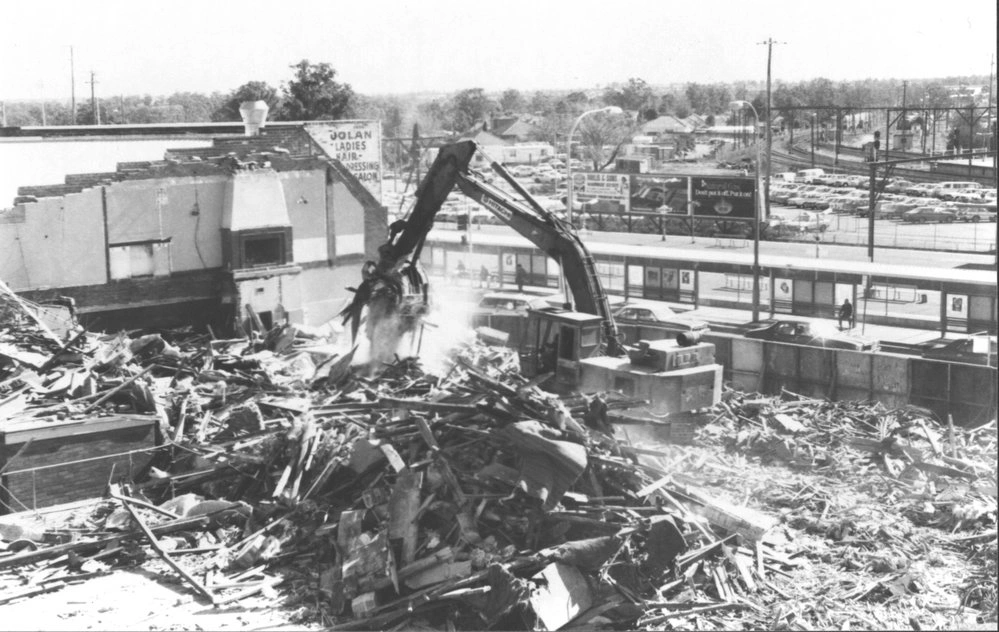
The Robin Hood Inn was demolished on August 12 1984. It stood on the site of the Royal Hotel, fronting Main Street, Blacktown. Railway platforms can be seen in the background.
Robin Hood Inn situated in Main Street (previously Blacktown Road), Blacktown. It was demolished in 1984.
The Robin Hood Inn was demolished overnight on August 12 1984. The hotel faced Main Street and was opposite the railway station. This photo is taken looking north (from the back of the hotel). The lounge and garden areas are still visible. The laneway on the right of the photograph is now called the Jim Simpson Laneway.
The Robin Hood Inn replaced the Royal Hotel, and was built in 1936 - 1937. It was situated in Main Street (previously Blacktown Road), Blacktown, near the railway station. The Robin Hood Inn was demolished in 1984. The site today (2013) is the location of the multi-storied State Government Office block.
The Robin Hood Inn was demolished on August 12 1984. It stood on the site of the Royal Hotel, fronting Main Street, Blacktown. Railway platforms can be seen in the background.
Bungarribee Estate
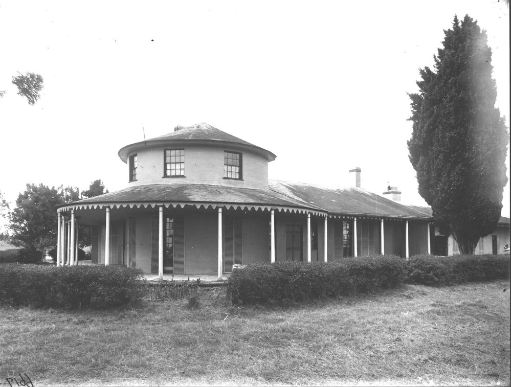
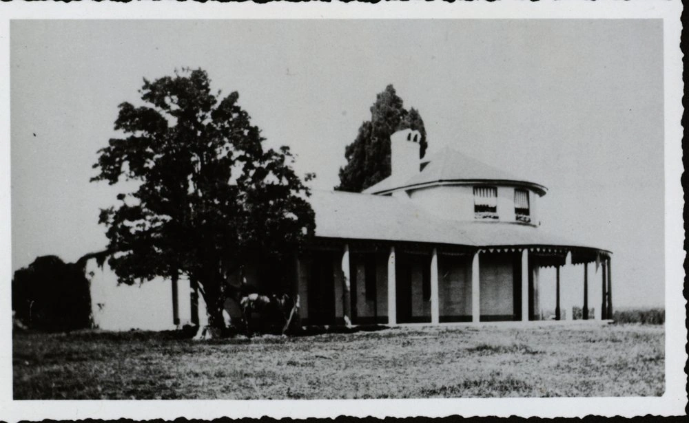
Bungarribee was 93 years old when this photo was taken in 1918. The house was built in the early 1800s and was demolished in 1957. The property was used by the Overseas Telecommunications Commission (OTC) after World War II. Photograph showing the front view of Bungarribee House.
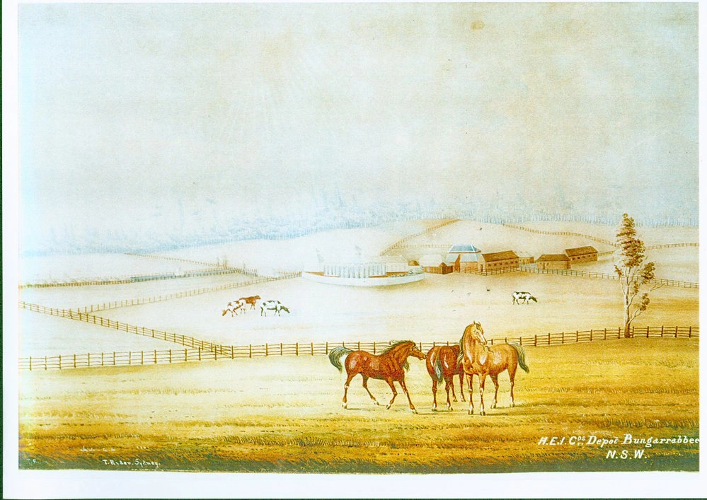
Copy of the water colour sketch "Bungarribee" by Thomas W. Rider, painted in 1845. This is one of the two paintings of Bungarribee estate completed during the ownership of British East India Company (H.E.I.Cos Depot Bungarribee)
The photograph shows the stables at Bungarribee, Doonside. The Bungarribee Estate once the home to Bungarribee House was built in 1825 by owner John Campbell. Over the years the property had many owners one being Thomas Icely who was a horse breeder. Bungarribee House was demolished in 1957 and the stables 1977. The property was used by the Overseas Telecommunications Commission (OTC) after World War II. Much of the property was subsumed by the Western Sydney Parklands, although part was zoned residential. The house site was retained as Bungarribee Homestead Park.
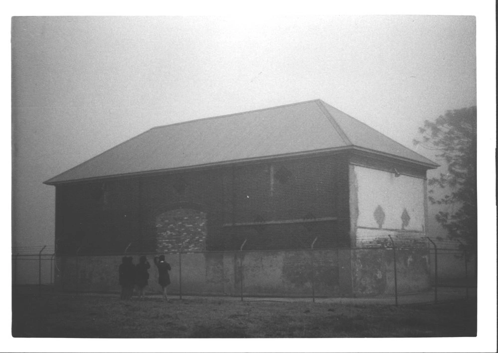
This photograph showing the stable at the Bungarribee estate. The Bungarribee Estate once the home to Bungarribee House built in 1825 by owner John Campbell. Over the years the property had many owners one being Thomas Icely who was a horse breeder. Bungarribee House was demolished in 1957 and the stables 1977. The property was used by the Overseas Telecommunications Commission after World War II. Much of the property was subsumed by the Western Sydney Parklands, although part was zoned residential. The house site was retained as Bungarribee Homestead Park.
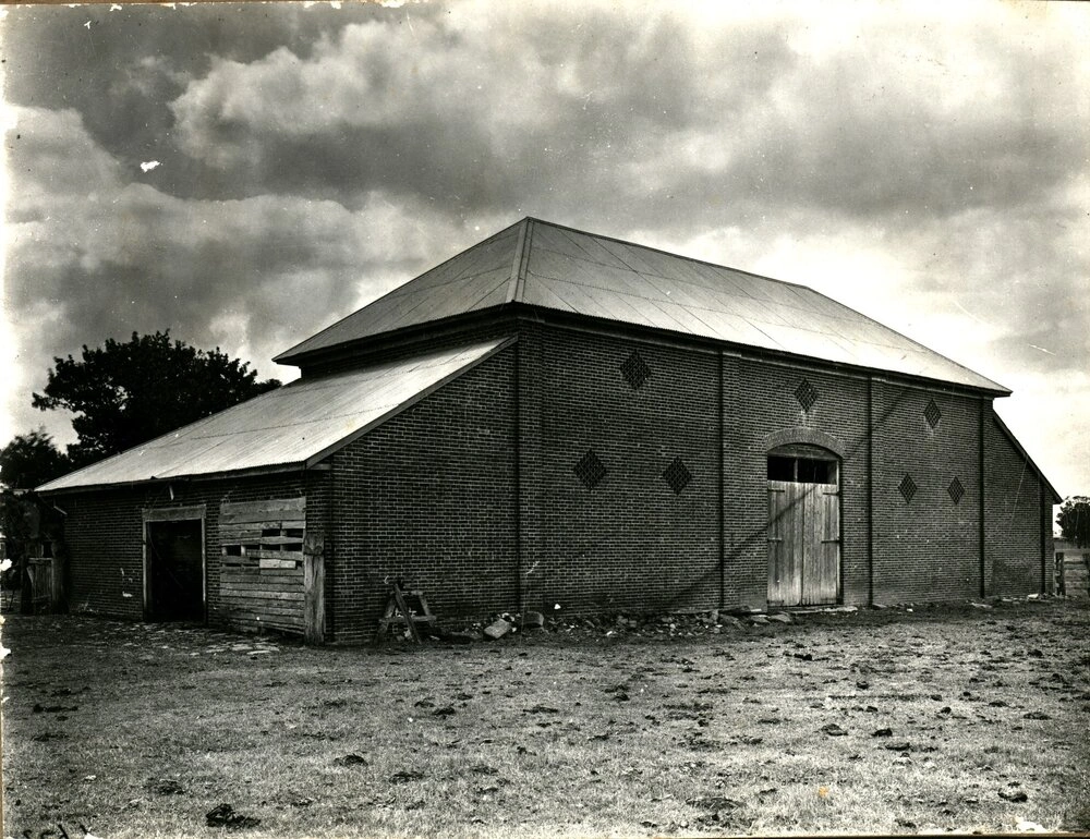
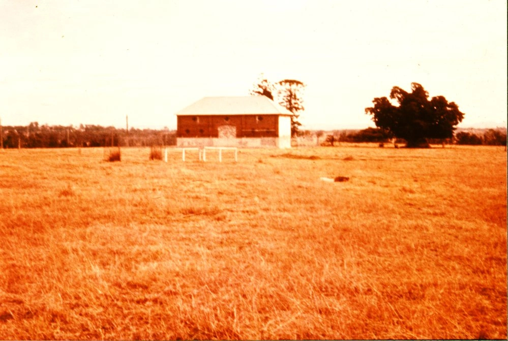
This photograph is of a barn that was located on the Bungarribee Estate.Bungarribee House was originally built in 1825 by John Campbell. Over the years the property had many owners, most who were involved in the breeding and keeping of horses. The property was used by the Overseas Telecommunications Commission after World War II. Demolished in the 1950s, the house site is now Bungarribee Homestead Park.
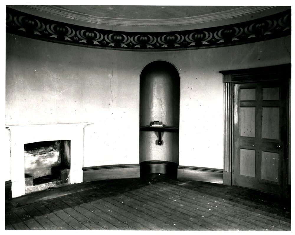
This photograph is of a room in Bungarribee house, taken in November 1918. The room appears round and shows a fireplace, an alcove and a door, and patterned ceiling.Bungarribee House was originally built in 1825 by John Campbell. Over the years the property had many owners, most of whom were involved in the breeding and keeping of horses. The property was used by the Overseas Telecommunications Commission after World War II. Demolished in the 1950s, the house site is now Bungarribee Homestead Park.
The house was built in the early 1800s and was demolished in 1957. The property was used by the Overseas Telecommunications Commission after World War II. Much of the property was subsumed by the Western Sydney Parklands, although part was zoned residential. The house site was retained as Bungarribee Homestead Park.
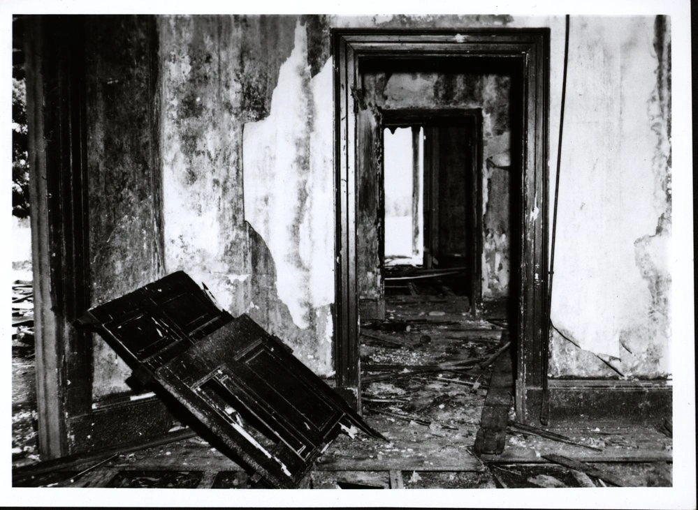
The house was built in the early 1800s and was demolished in 1957. The property was used by the Overseas Telecommunications Commission (OTC) after World War II. Much of the property was subsumed by the Western Sydney Parklands, although part was zoned residential. The house site was retained as Bungarribee Homestead Park. Bungarribee House at time of demolition in this photograph.
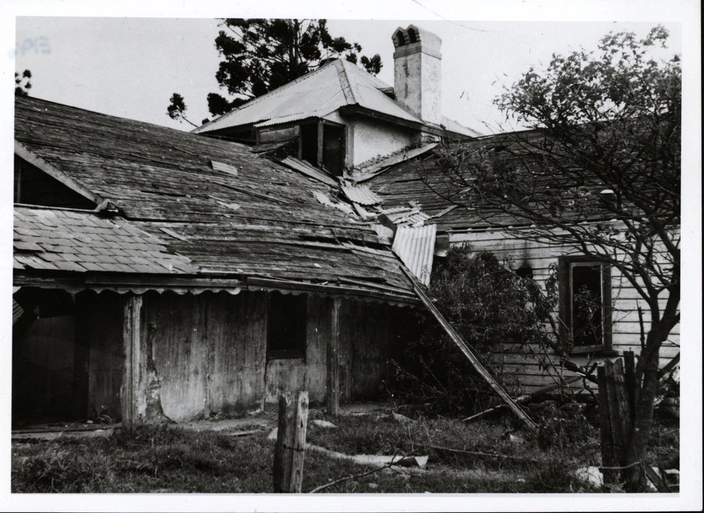
The house was built in the early 1800s and was demolished in 1957. The property was used by the Overseas Telecommunications Commission (OTC) after World War II. Much of the property was subsumed by the Western Sydney Parklands, although part was zoned residential. The house site was retained as Bungarribee Homestead Park. Bungarribee House at time of demolition in this photograph.
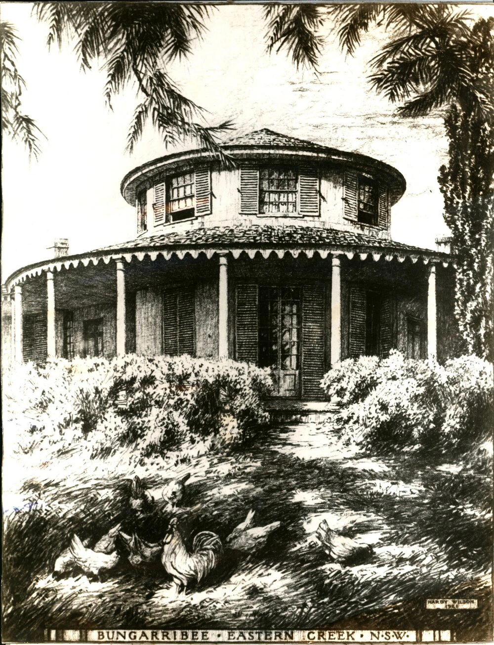
Copy of a sketch completed by Hardy Wilson in 1921 of Bungarribee homestead, Eastern Creek. The home was originally built in 1824 by pioneer merchant John Campbell on 2000 acres of land. Other owners have been Thomas Icely, Henry Kater, The East India Company, and the Cleeve family.William Hardy Wilson (1881- 1955) was an architect known for his drawings of Australian colonial buildings.
Bungarribee was 93 years old when this photo was taken in 1918. The house was built in the early 1800s and was demolished in 1957. The property was used by the Overseas Telecommunications Commission (OTC) after World War II. Photograph showing the front view of Bungarribee House.
Copy of the water colour sketch "Bungarribee" by Thomas W. Rider, painted in 1845. This is one of the two paintings of Bungarribee estate completed during the ownership of British East India Company (H.E.I.Cos Depot Bungarribee)
The photograph shows the stables at Bungarribee, Doonside. The Bungarribee Estate once the home to Bungarribee House was built in 1825 by owner John Campbell. Over the years the property had many owners one being Thomas Icely who was a horse breeder. Bungarribee House was demolished in 1957 and the stables 1977. The property was used by the Overseas Telecommunications Commission (OTC) after World War II. Much of the property was subsumed by the Western Sydney Parklands, although part was zoned residential. The house site was retained as Bungarribee Homestead Park.
This photograph showing the stable at the Bungarribee estate. The Bungarribee Estate once the home to Bungarribee House built in 1825 by owner John Campbell. Over the years the property had many owners one being Thomas Icely who was a horse breeder. Bungarribee House was demolished in 1957 and the stables 1977. The property was used by the Overseas Telecommunications Commission after World War II. Much of the property was subsumed by the Western Sydney Parklands, although part was zoned residential. The house site was retained as Bungarribee Homestead Park.
This photograph is of a barn that was located on the Bungarribee Estate.Bungarribee House was originally built in 1825 by John Campbell. Over the years the property had many owners, most who were involved in the breeding and keeping of horses. The property was used by the Overseas Telecommunications Commission after World War II. Demolished in the 1950s, the house site is now Bungarribee Homestead Park.
This photograph is of a room in Bungarribee house, taken in November 1918. The room appears round and shows a fireplace, an alcove and a door, and patterned ceiling.Bungarribee House was originally built in 1825 by John Campbell. Over the years the property had many owners, most of whom were involved in the breeding and keeping of horses. The property was used by the Overseas Telecommunications Commission after World War II. Demolished in the 1950s, the house site is now Bungarribee Homestead Park.
The house was built in the early 1800s and was demolished in 1957. The property was used by the Overseas Telecommunications Commission after World War II. Much of the property was subsumed by the Western Sydney Parklands, although part was zoned residential. The house site was retained as Bungarribee Homestead Park.
The house was built in the early 1800s and was demolished in 1957. The property was used by the Overseas Telecommunications Commission (OTC) after World War II. Much of the property was subsumed by the Western Sydney Parklands, although part was zoned residential. The house site was retained as Bungarribee Homestead Park. Bungarribee House at time of demolition in this photograph.
The house was built in the early 1800s and was demolished in 1957. The property was used by the Overseas Telecommunications Commission (OTC) after World War II. Much of the property was subsumed by the Western Sydney Parklands, although part was zoned residential. The house site was retained as Bungarribee Homestead Park. Bungarribee House at time of demolition in this photograph.
Copy of a sketch completed by Hardy Wilson in 1921 of Bungarribee homestead, Eastern Creek. The home was originally built in 1824 by pioneer merchant John Campbell on 2000 acres of land. Other owners have been Thomas Icely, Henry Kater, The East India Company, and the Cleeve family.William Hardy Wilson (1881- 1955) was an architect known for his drawings of Australian colonial buildings.
Mount Druitt Racetrack
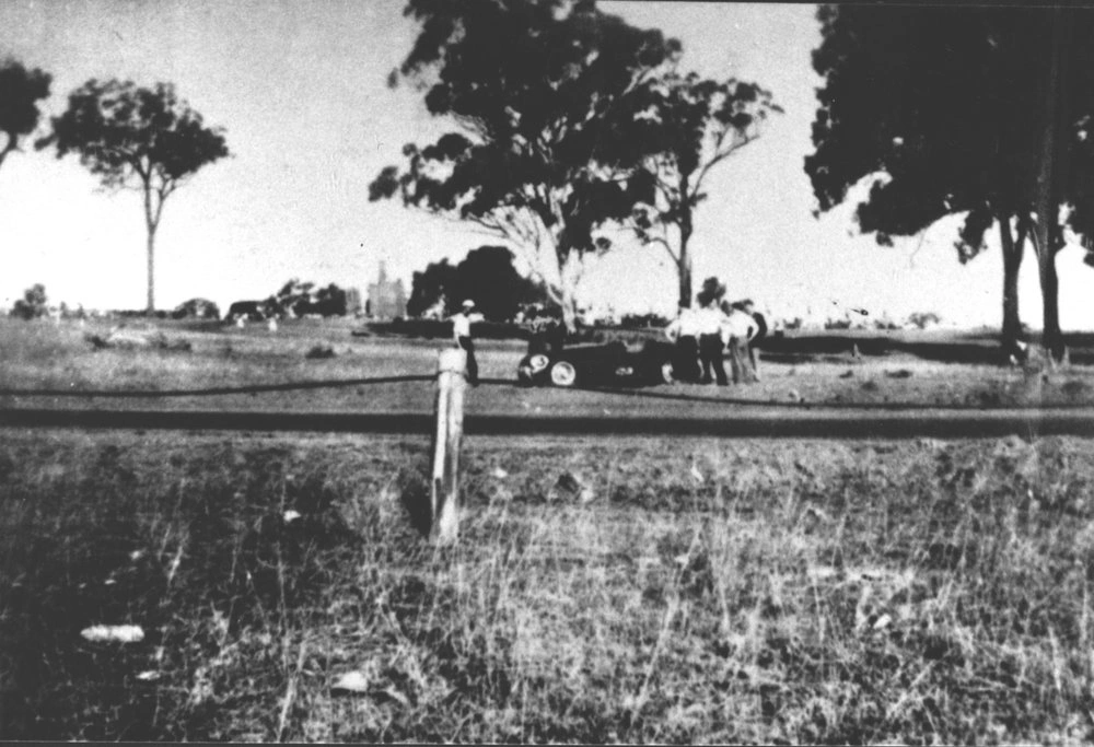
Mt Druitt Racetrack (formerly WWII RAAF Base) opened in 1948 as 2.9 km and was extended to 3.6km in 1952. Each race day attracted over 15,000 people. The last race was held in November 1957. This photograph was featured in 2006 Blacktown City Calendar.Photo sizeDigitalDate1940s-1950s
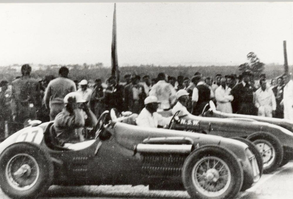
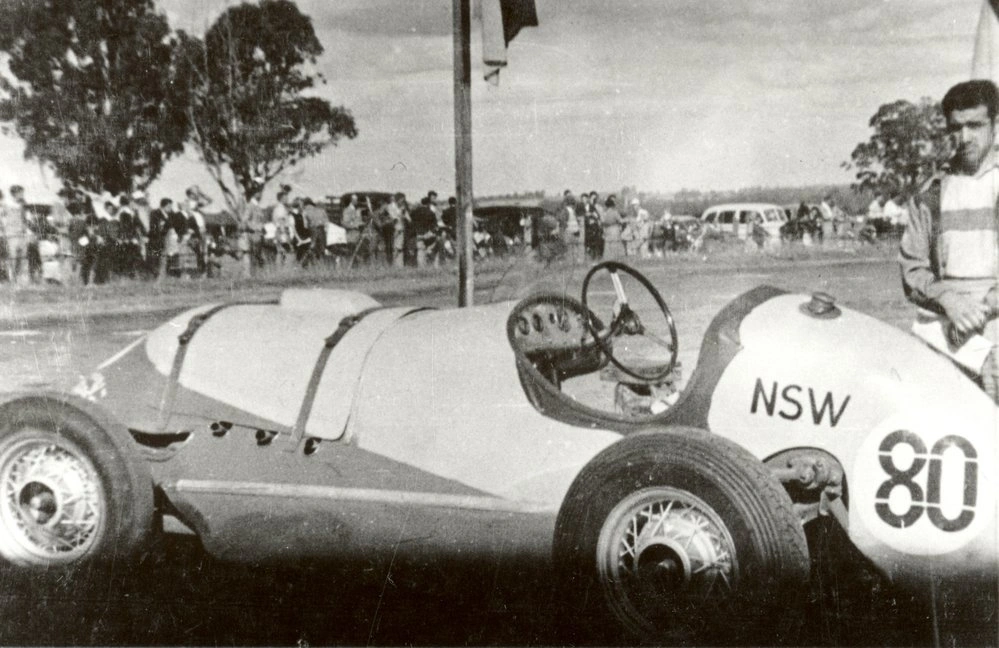
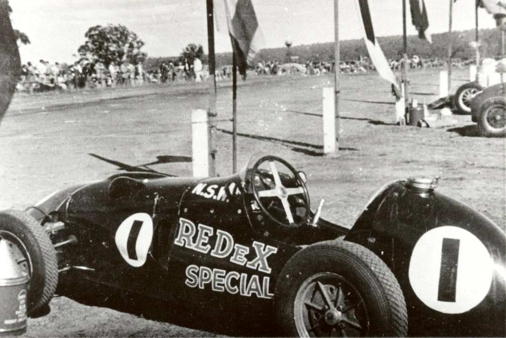
Portion of Mt Druitt's Motor Racing circuit, from 1948-1958, looking North towards the burntout shell of 'Centenary House' (among the trees) built in 1888, was used as a clubhouse by the Australian Sporting Car Club until it was destroyed by fire in late 1950s. It was also the headquarters for RAAF No 6 Repair & Salvage Unit (RSU) in WWII. Dick Cobden's 'Ferrari' racing car. This racing circuit was formerly on portion of the McMahon Estate.
Mt Druitt Racetrack (formerly WWII RAAF Base) opened in 1948 at 2.9 km and was extended to 3.6km in 1952. Each race day attracted over 15,000 people. The last race was held in November 1957.
Mt Druitt Racetrack (formerly WWII RAAF Base) opened in 1948 as 2.9 km and was extended to 3.6km in 1952. Each race day attracted over 15,000 people. The last race was held in November 1957. This photograph was featured in 2006 Blacktown City Calendar.Photo sizeDigitalDate1940s-1950s
Portion of Mt Druitt's Motor Racing circuit, from 1948-1958, looking North towards the burntout shell of 'Centenary House' (among the trees) built in 1888, was used as a clubhouse by the Australian Sporting Car Club until it was destroyed by fire in late 1950s. It was also the headquarters for RAAF No 6 Repair & Salvage Unit (RSU) in WWII. Dick Cobden's 'Ferrari' racing car. This racing circuit was formerly on portion of the McMahon Estate.
Mt Druitt Racetrack (formerly WWII RAAF Base) opened in 1948 at 2.9 km and was extended to 3.6km in 1952. Each race day attracted over 15,000 people. The last race was held in November 1957.
Westpoint Shopping Centre
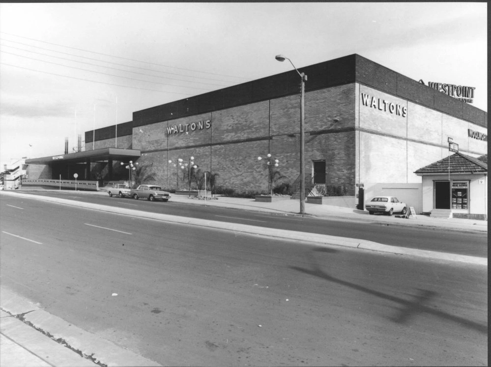
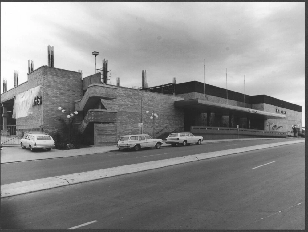
Construction nearly completed, image showing the Patrick Street entry. Image taken before Blacktown Westpoint Shopping centre officially opened on 9 April 1973. A real estate business can also be seen in this photograph.
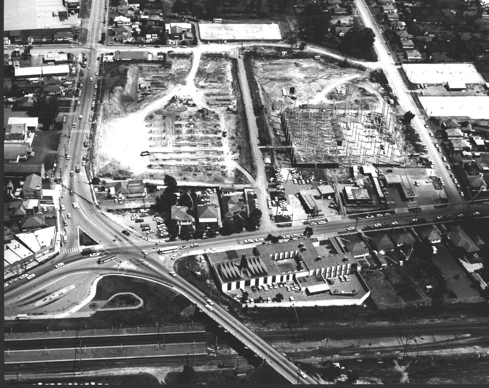
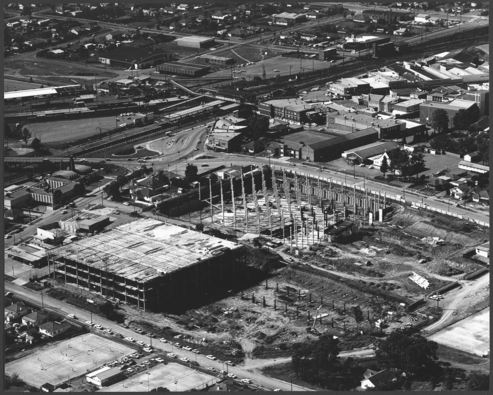
Aerial view showing the start of construction for Blacktown Westpoint Shopping Centre. Patrick Street (on the left) and Balmoral Street (on the right), Alpha Street (on the top) and Kildare Road (bottom) can be seen. The street in the middle of the image, joining Kildare Road and Alpha Street is Austral Street which was closed in November 1971 as part of the Westpoint construction.
1972 Showing the progress of the construction, the image looking towards the railway station, showing the corner of Patrick Street and Kildare Road. Boys Avenue, Prince Street and First Avenue can be seen on the other side of the station.
Construction of Westpoint shopping centre near completion, the image taken before the opening showing the Patrick Street entry. The Woolworths sign still unveiled.
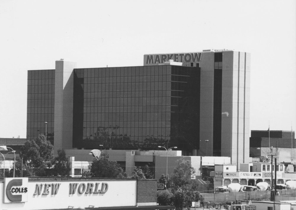
Westpoint Office Building, known for several years in the 1980s as Marketown but later renamed back to Westpoint, prior to the extensions which completely covered Patrick Street, which can be seen in the lower right with the cement trucks. The photo is taken from the top of the Kmart car park, when the Coles New World Supermarket still occupied the northern part of the Kmart building.
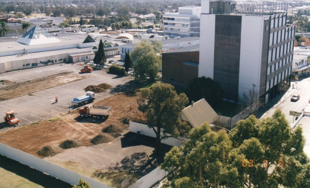
2003 Land being prepared for the expansion of Blacktown Westpoint, image showing Patrick Mall before its demolition. Blacktown Public School and Telstra Exchange building can also be seen.
Construction nearly completed, image showing the Patrick Street entry. Image taken before Blacktown Westpoint Shopping centre officially opened on 9 April 1973. A real estate business can also be seen in this photograph.
Aerial view showing the start of construction for Blacktown Westpoint Shopping Centre. Patrick Street (on the left) and Balmoral Street (on the right), Alpha Street (on the top) and Kildare Road (bottom) can be seen. The street in the middle of the image, joining Kildare Road and Alpha Street is Austral Street which was closed in November 1971 as part of the Westpoint construction.
1972 Showing the progress of the construction, the image looking towards the railway station, showing the corner of Patrick Street and Kildare Road. Boys Avenue, Prince Street and First Avenue can be seen on the other side of the station.
Construction of Westpoint shopping centre near completion, the image taken before the opening showing the Patrick Street entry. The Woolworths sign still unveiled.
Westpoint Office Building, known for several years in the 1980s as Marketown but later renamed back to Westpoint, prior to the extensions which completely covered Patrick Street, which can be seen in the lower right with the cement trucks. The photo is taken from the top of the Kmart car park, when the Coles New World Supermarket still occupied the northern part of the Kmart building.
2003 Land being prepared for the expansion of Blacktown Westpoint, image showing Patrick Mall before its demolition. Blacktown Public School and Telstra Exchange building can also be seen.
Blacktown Train Station
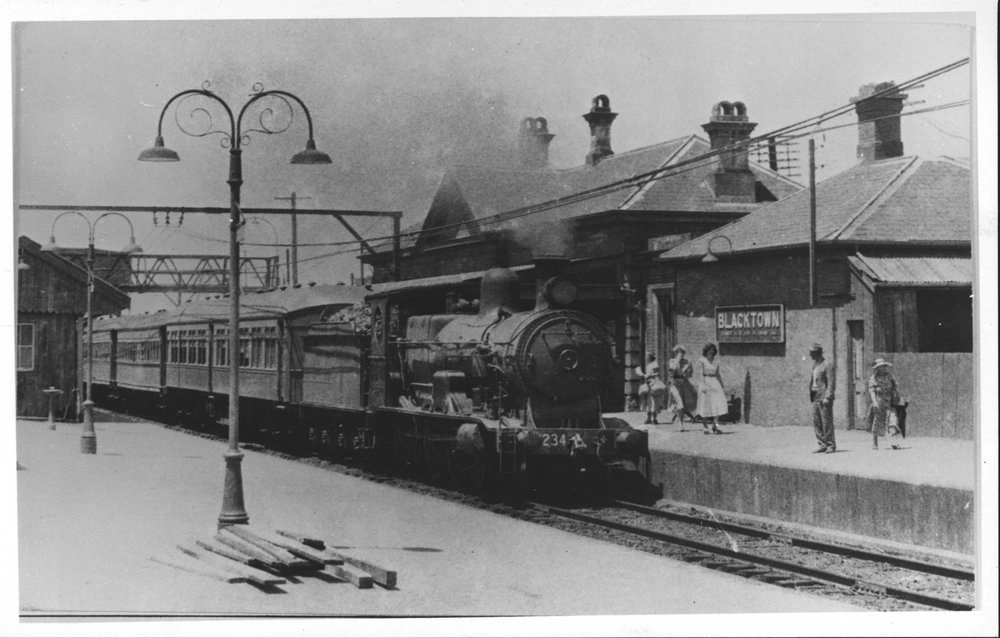
Photograph of steam train at Blacktown railway station taken in January 1955, a month before the completion of electrification of the line.
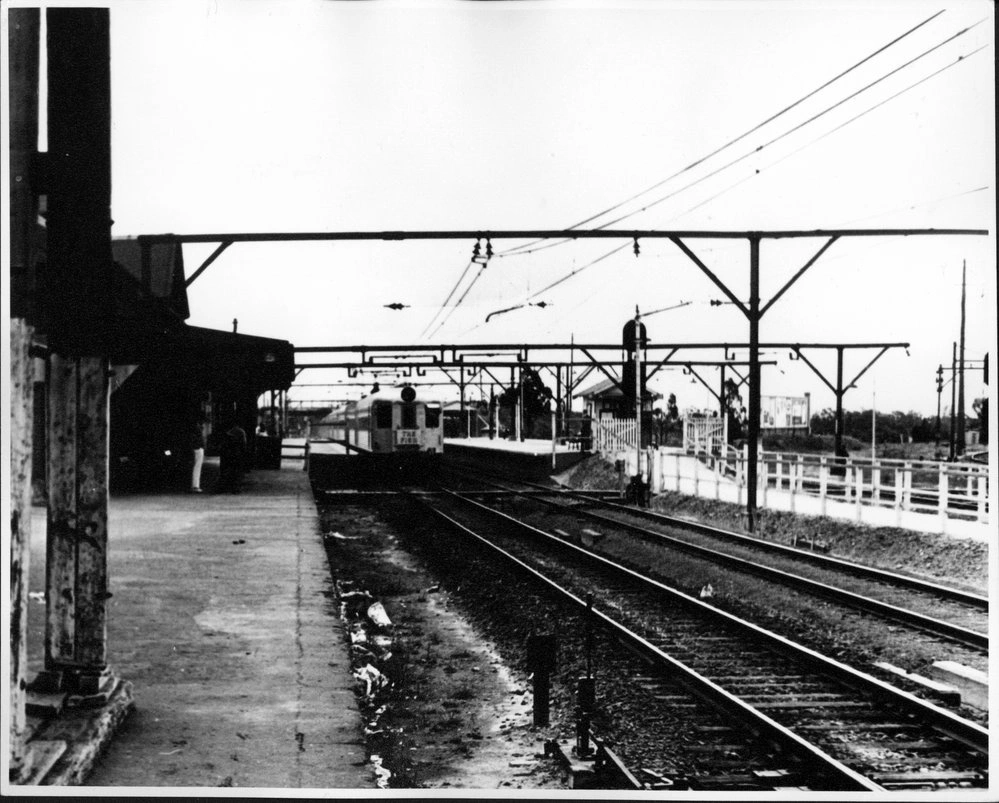
Blacktown railway station, after electrification of the lines. The Fish, an express train to the Blue Mountains, can be seen at the current Platform 5. The 1889 station can be seen on the left of the photograph.
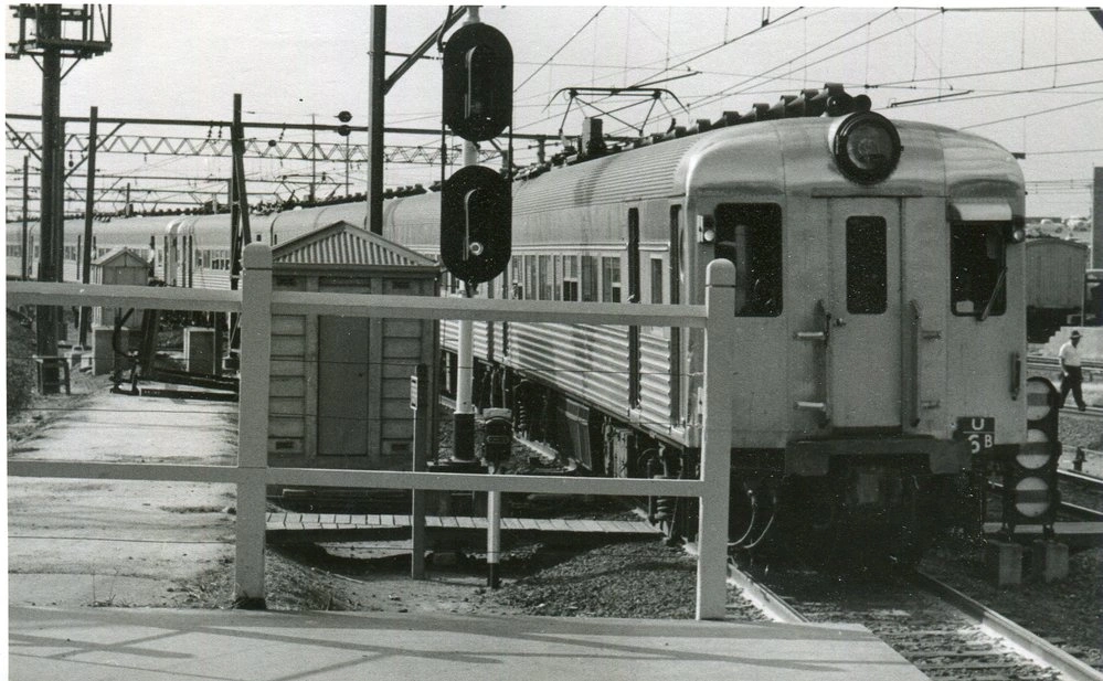
32 Sydney train arriving Blacktown. Photograph of Set U6B single deck electric interurban train, taken by Carl Syme.

Photograph of CPH railmotor 14 alongside Platform No 1, Richmond Line at Blacktown railway station. Photograph taken by Carl Syme.
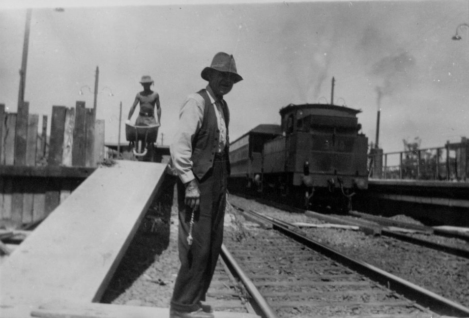
Flagman at Blacktown railway station, sometime between 1930 and 1950. Construction work is being carried on at the station. Formwork can be seen at the end of the platform and a workman is pushing a wheelbarrow. A steam train is stopped at one of the platforms.
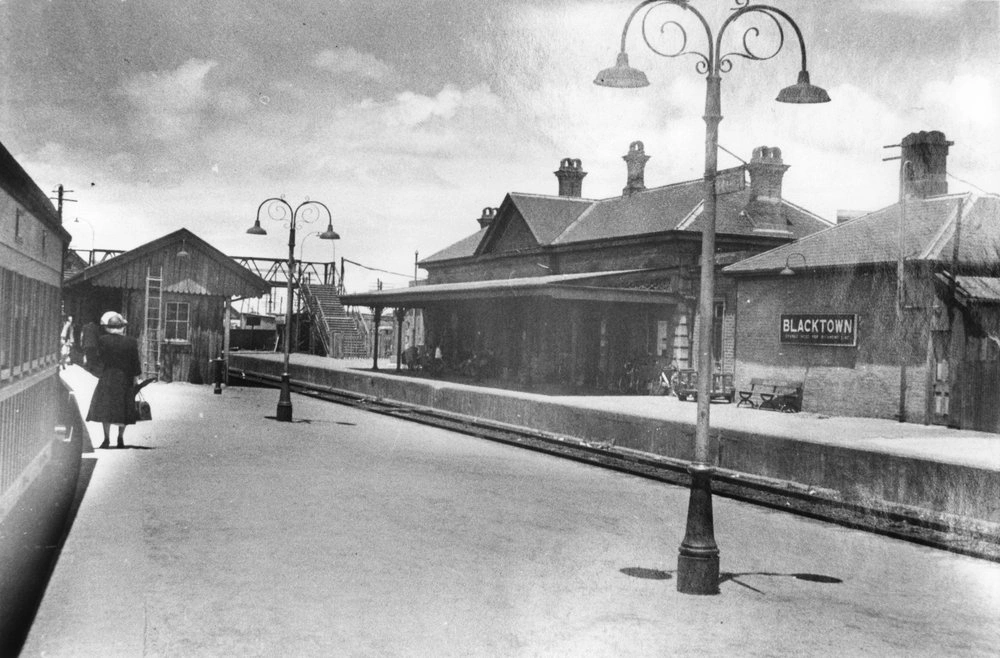
Blacktown Railway Station showing two platforms and 1886 station building. Train at platform, people on platform, lampposts.
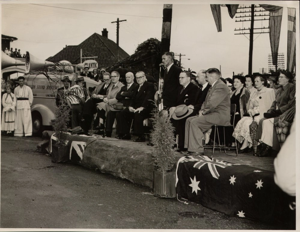
The first electric train service to Blacktown was officially opened on 26 February 1955 by the Premier of N.S.W., Mr John Joseph Cahill. The first electric train ran seven miles and 17 chains between Parramatta and Blacktown. Premier Cahill (centre left), Shire President John Sidney (Jack) Bromfield (in the centre) and MP for Mitchell Roy Wheeler (Centre right).
Photograph of steam train at Blacktown railway station taken in January 1955, a month before the completion of electrification of the line.
Blacktown railway station, after electrification of the lines. The Fish, an express train to the Blue Mountains, can be seen at the current Platform 5. The 1889 station can be seen on the left of the photograph.
32 Sydney train arriving Blacktown. Photograph of Set U6B single deck electric interurban train, taken by Carl Syme.
Photograph of CPH railmotor 14 alongside Platform No 1, Richmond Line at Blacktown railway station. Photograph taken by Carl Syme.
Flagman at Blacktown railway station, sometime between 1930 and 1950. Construction work is being carried on at the station. Formwork can be seen at the end of the platform and a workman is pushing a wheelbarrow. A steam train is stopped at one of the platforms.
Blacktown Railway Station showing two platforms and 1886 station building. Train at platform, people on platform, lampposts.
The first electric train service to Blacktown was officially opened on 26 February 1955 by the Premier of N.S.W., Mr John Joseph Cahill. The first electric train ran seven miles and 17 chains between Parramatta and Blacktown. Premier Cahill (centre left), Shire President John Sidney (Jack) Bromfield (in the centre) and MP for Mitchell Roy Wheeler (Centre right).