Historical Blacktown - Galleries
Transport around Blacktown
The history of transport around Blacktown traces its journey from early bush tracks and horse-drawn carts to the arrival of the railway in the 1860s
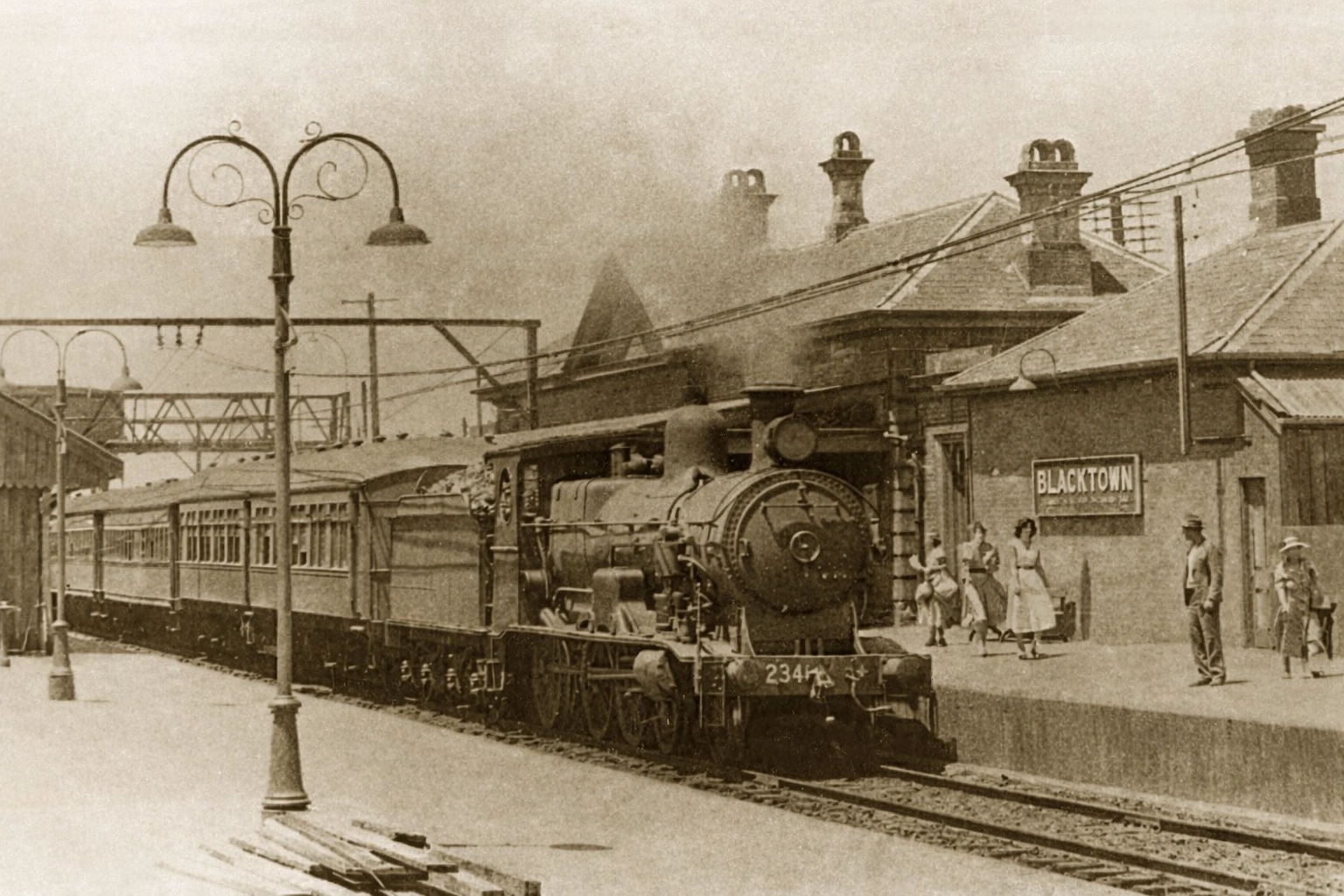
Blacktown Railway Station, 1955, State Records, NSW
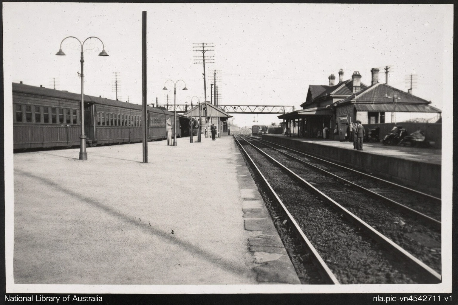
Blacktown Railway Station in 1947. Photo: National Library of Australia collection
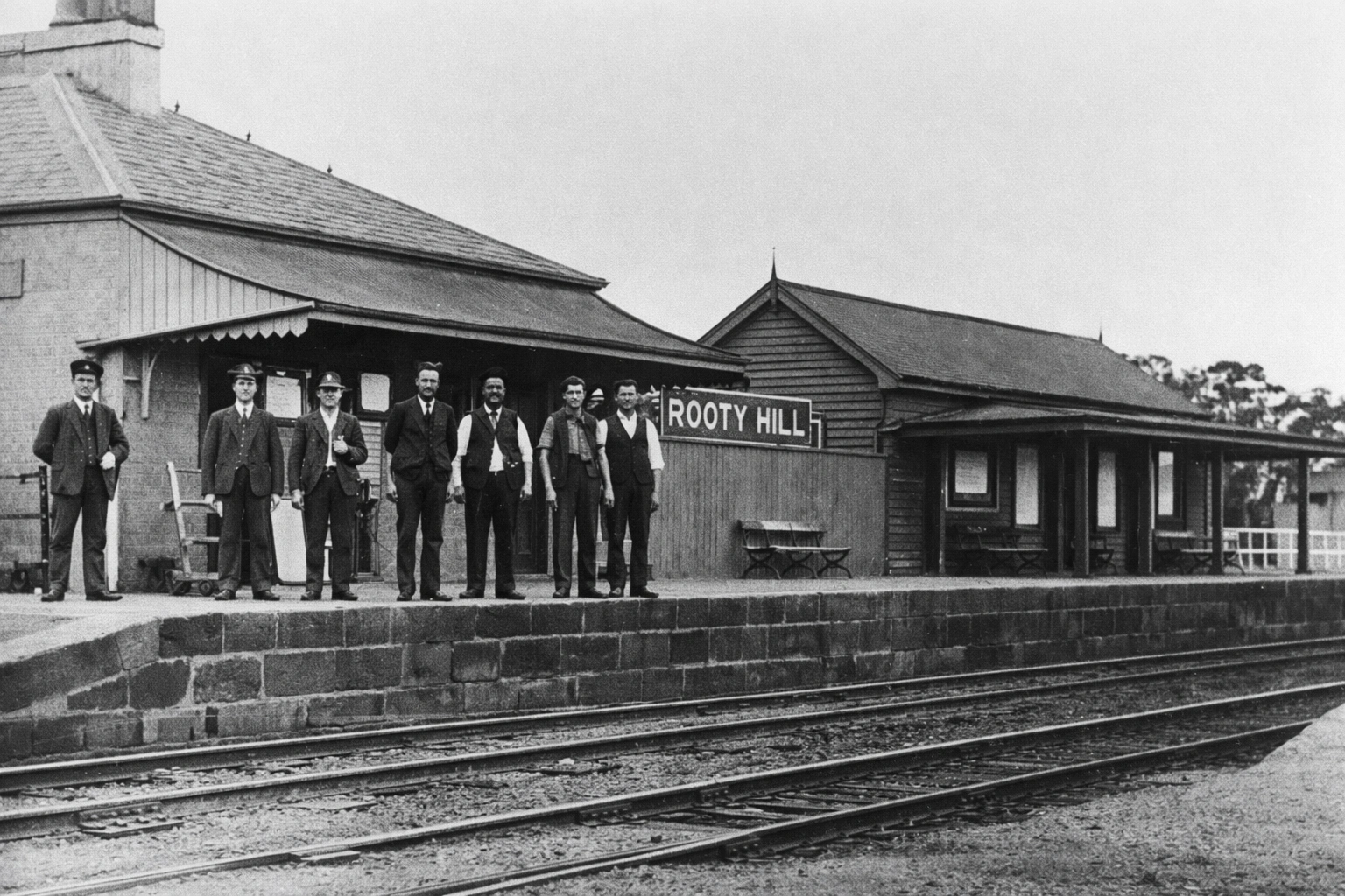
Rooty Hill Railway Station (Date unknown)
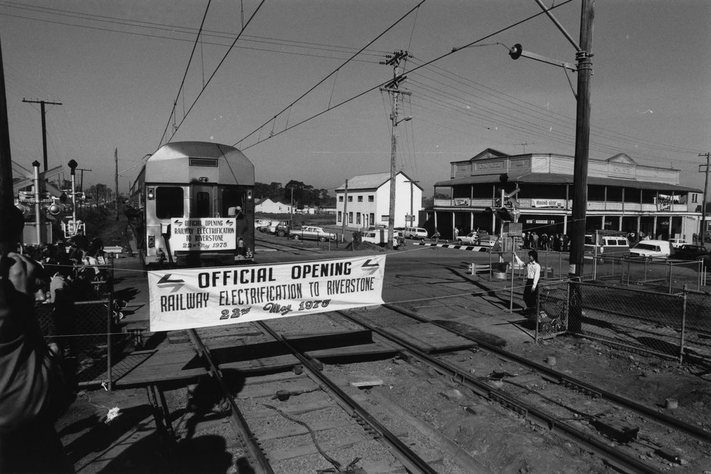
The official train arrived on 22nd May 1975, celebrating the electrification of the railway line to Riverstone. The Royal Hotel can be seen in the background on Garfield Road.
Donor: George Nicolaidis
Blacktown Railway Station, 1955, State Records, NSW
Blacktown Railway Station in 1947. Photo: National Library of Australia collection
Rooty Hill Railway Station (Date unknown)
The official train arrived on 22nd May 1975, celebrating the electrification of the railway line to Riverstone. The Royal Hotel can be seen in the background on Garfield Road.
Donor: George Nicolaidis
Educating Blacktown District
Education in Blacktown has grown from small colonial-era classrooms to a diverse network of primary schools, high schools, and tertiary institutions.
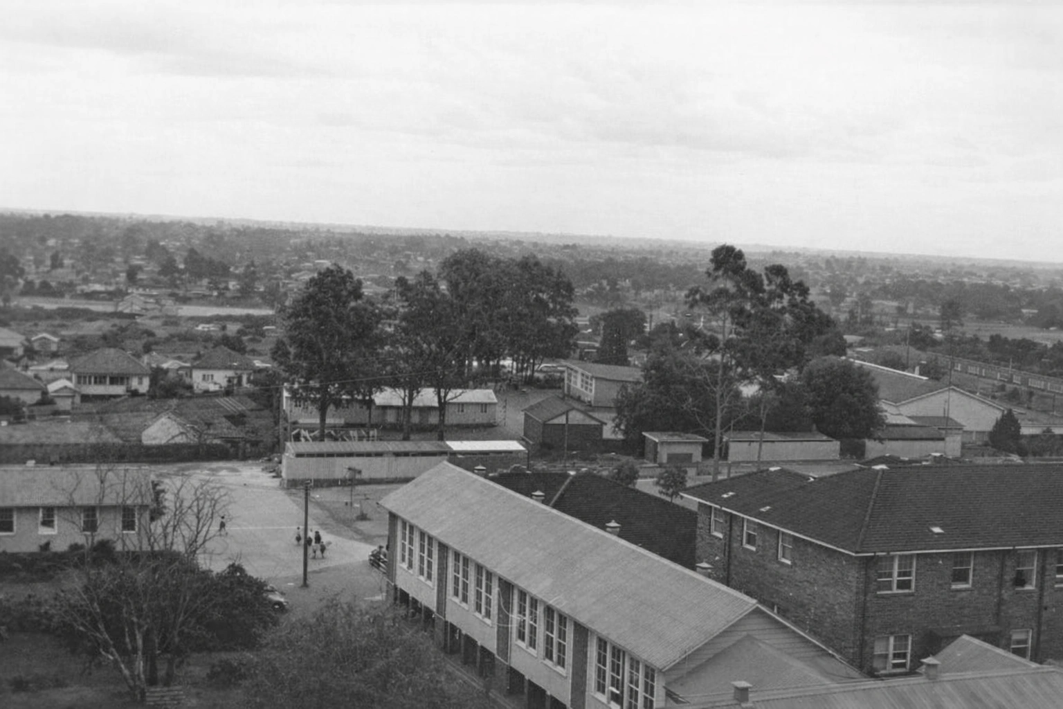
View of Blacktown looking west taken from the roof of Blacktown Council building. Blacktown Public and St Patrick's Primary schools can be seen. Photo: Blacktown City Libraries
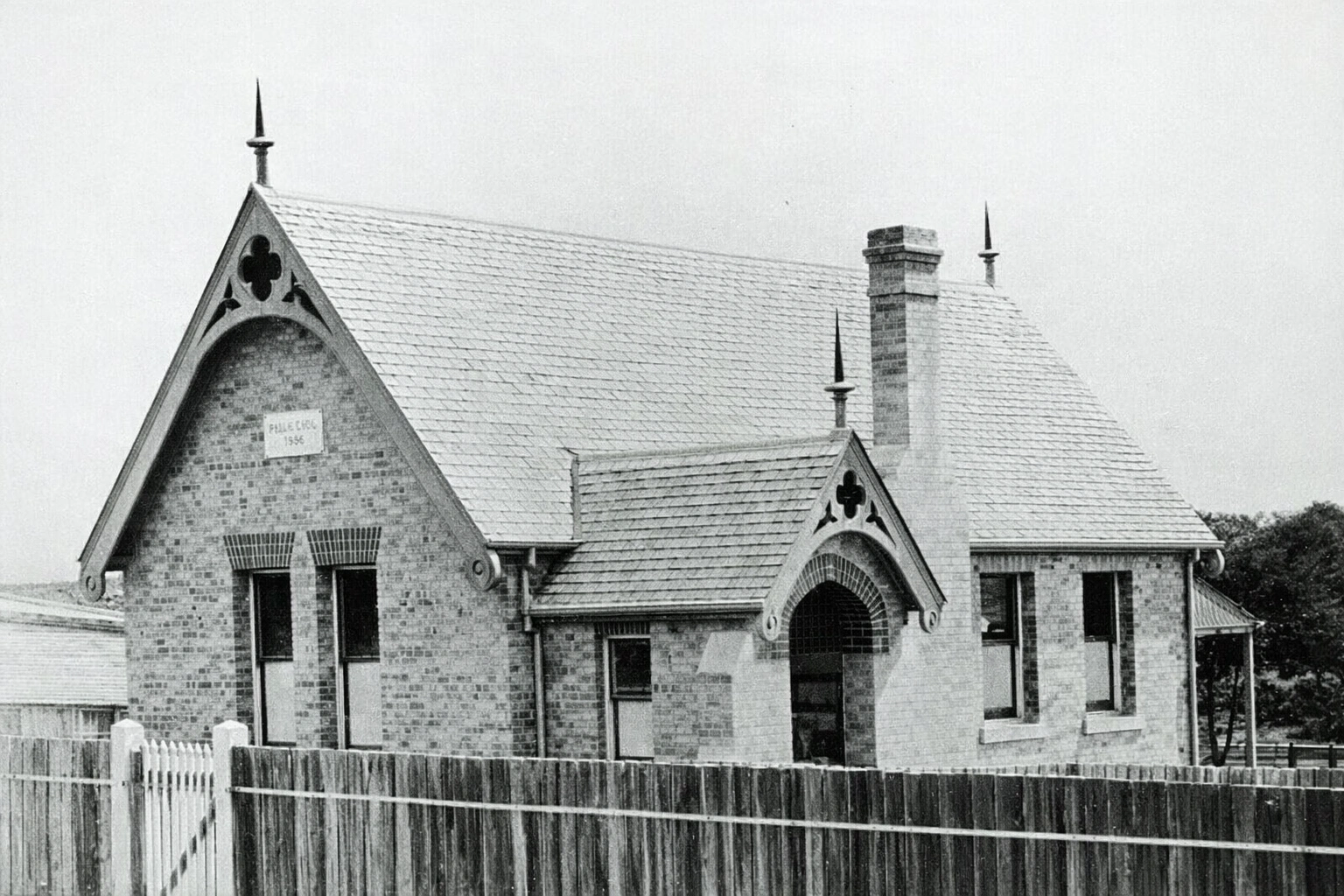
Blacktown Public School (year unknown). This building was built in 1876. Photo State Records of NSW collection.
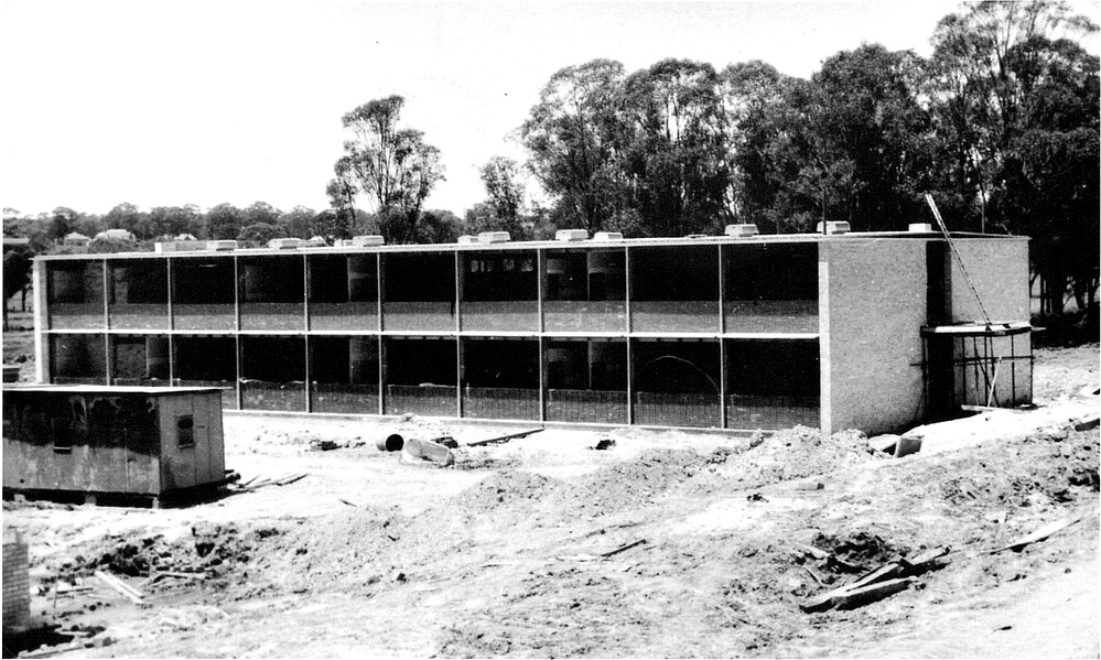
The school opened in May 1964 as Blacktown South High School. Name changed to Mitchell High School in June 1964.Two storey classroom block under construction.
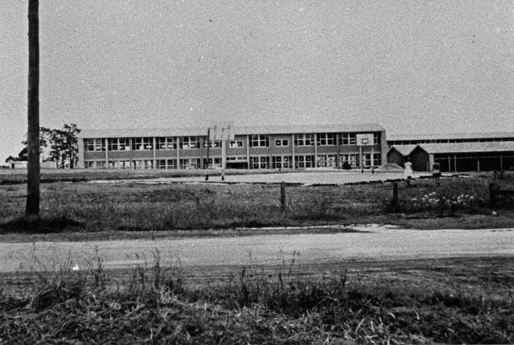
The photograph of Blacktown High School, looking from Sunnyholt Road, was taken shortly after the school was built. Established in 1956, the school was originally known as Blacktown High School. A decision was later made to establish separate high schools for boys and girls. Blacktown Boys High School was officially opened on 17 October 1959 by the Deputy Premier and Minister of Education, Bob Heffron. The school became a partially selective high school in 2010.
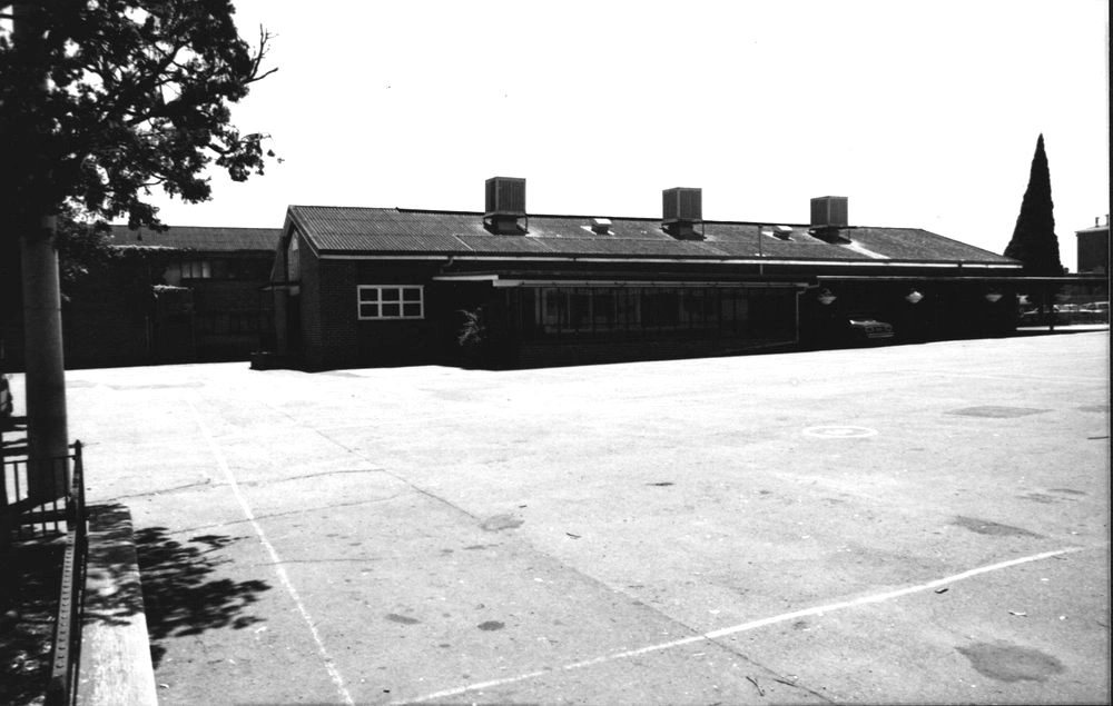
The sisters of Mercy from Parramatta opened a Primary School in 1919 in the porch of the old Church in Patrick Street. The school building was completed and opened in 1952. With the beginning of secondary school studies (for girls) in 1953, St Patrick's became the first Intermediate High School in Blacktown.
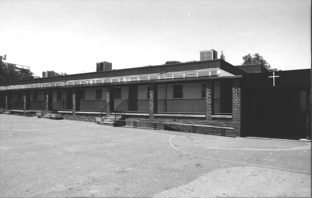
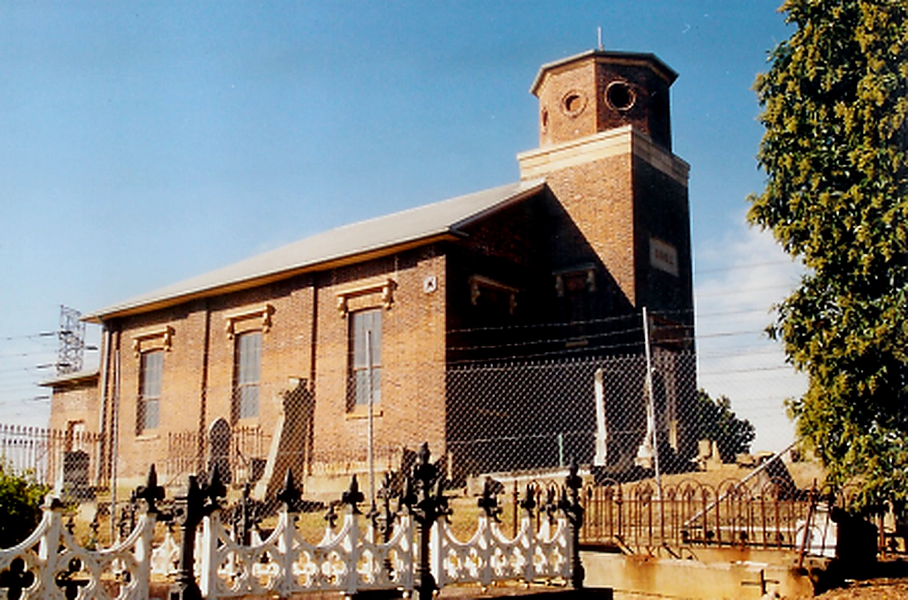
The photograph shows the school classrooms and church. The original St Patrick's Church was built in 1892 and demolished in 1974.
St Patrick's School was located on Patrick Street, Blacktown until 1986 when it was relocated to Allawah Street, Blacktown. The school was started by The Sisters of Mercy from Parramatta in 1919 in the old
St Patrick's Church. The Church had served as both church and school until 1952 when a two storey building was built, the school was extended to a high school for girls only.
View of Blacktown looking west taken from the roof of Blacktown Council building. Blacktown Public and St Patrick's Primary schools can be seen. Photo: Blacktown City Libraries
Blacktown Public School (year unknown). This building was built in 1876. Photo State Records of NSW collection.
The school opened in May 1964 as Blacktown South High School. Name changed to Mitchell High School in June 1964.Two storey classroom block under construction.
The photograph of Blacktown High School, looking from Sunnyholt Road, was taken shortly after the school was built. Established in 1956, the school was originally known as Blacktown High School. A decision was later made to establish separate high schools for boys and girls. Blacktown Boys High School was officially opened on 17 October 1959 by the Deputy Premier and Minister of Education, Bob Heffron. The school became a partially selective high school in 2010.
The sisters of Mercy from Parramatta opened a Primary School in 1919 in the porch of the old Church in Patrick Street. The school building was completed and opened in 1952. With the beginning of secondary school studies (for girls) in 1953, St Patrick's became the first Intermediate High School in Blacktown.
The photograph shows the school classrooms and church. The original St Patrick's Church was built in 1892 and demolished in 1974.
St Patrick's School was located on Patrick Street, Blacktown until 1986 when it was relocated to Allawah Street, Blacktown. The school was started by The Sisters of Mercy from Parramatta in 1919 in the old
St Patrick's Church. The Church had served as both church and school until 1952 when a two storey building was built, the school was extended to a high school for girls only.
Our Health
Health in Blacktown has grown from small rural services into a major regional healthcare hub serving Western Sydney’s expanding population.
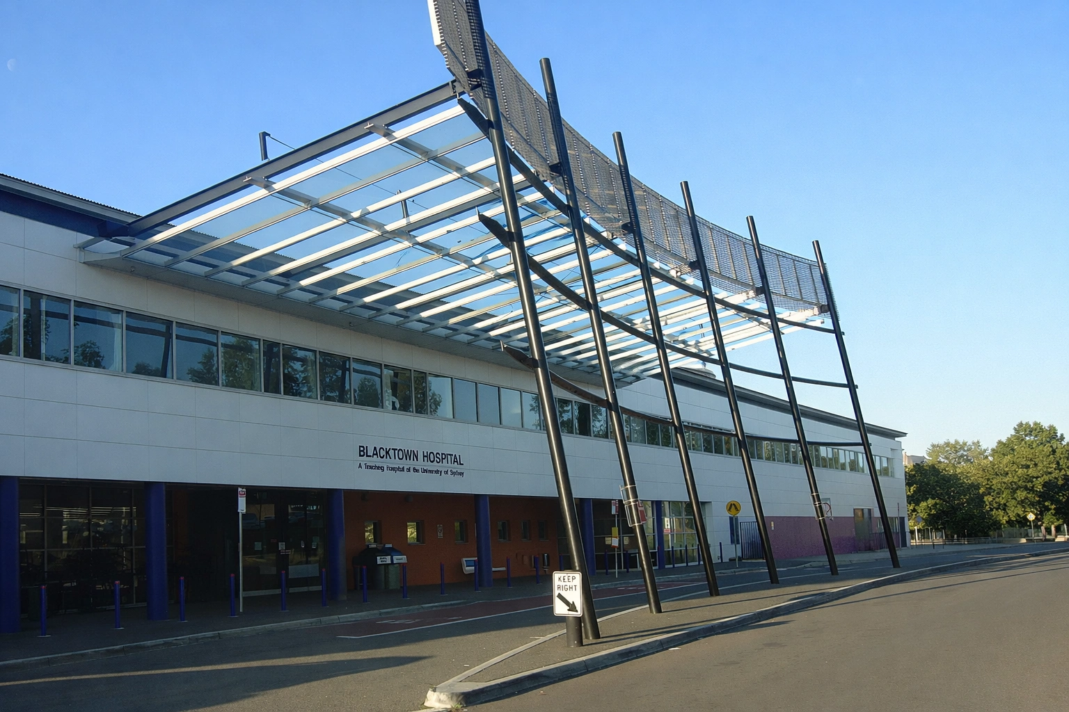
Blacktown Hospital Entrance 2007
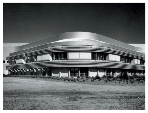
Mr Druitt Hospital, designed by architect Professor Lawrence Nield
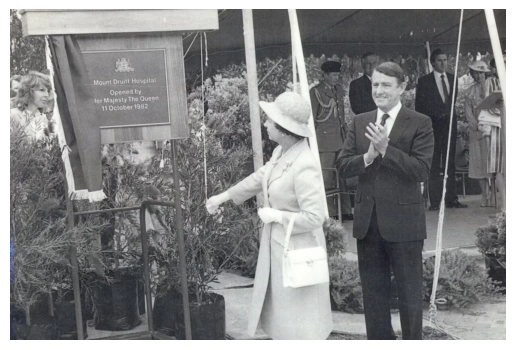
The opening of Mount Druitt Hospital on 11 October 1982 by Her Majesty, the Queen Elizabeth II, marked a vital move towards equity and social justice for the people of Sydney’s west. Image showing Her Majesty unveiling the plaque in the company of former NSW Premier, Neville Wran. This photograph was featured in 2006 Blacktown City Calendar.
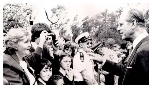
Thousands crowded onto the grounds of the new Mt Druitt Hospital on that historic Monday to catch a glimpse of Queen Elizabeth II and Prince Philip. 11 October 1982
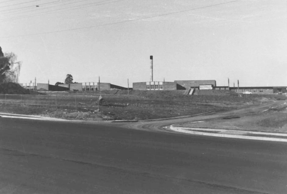
Blacktown District Hospital was opened in 1965. This photograph was taken during construction in August 1964. The hospital is now known as Blacktown Hospital.
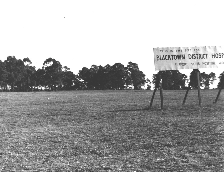
This photograph shows the site on which Blacktown Hospital was built. In 1956 the Blacktown Hospital board acquired the 28 acre site. The Blacktown Hospital is located at 18 Blacktown Road, Blacktown.
Blacktown Hospital Entrance 2007
Mr Druitt Hospital, designed by architect Professor Lawrence Nield
The opening of Mount Druitt Hospital on 11 October 1982 by Her Majesty, the Queen Elizabeth II, marked a vital move towards equity and social justice for the people of Sydney’s west. Image showing Her Majesty unveiling the plaque in the company of former NSW Premier, Neville Wran. This photograph was featured in 2006 Blacktown City Calendar.
Thousands crowded onto the grounds of the new Mt Druitt Hospital on that historic Monday to catch a glimpse of Queen Elizabeth II and Prince Philip. 11 October 1982
Blacktown District Hospital was opened in 1965. This photograph was taken during construction in August 1964. The hospital is now known as Blacktown Hospital.
This photograph shows the site on which Blacktown Hospital was built. In 1956 the Blacktown Hospital board acquired the 28 acre site. The Blacktown Hospital is located at 18 Blacktown Road, Blacktown.
Places of Worship
Places of worship in Blacktown reflect the area’s rich cultural diversity, evolving from early colonial churches to a wide range of modern faith centres
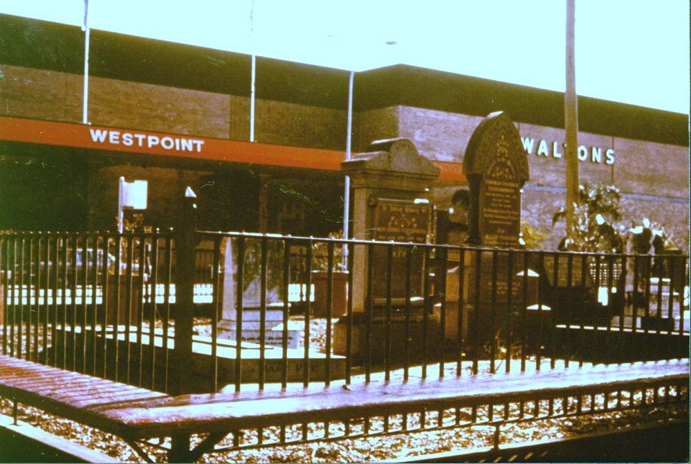
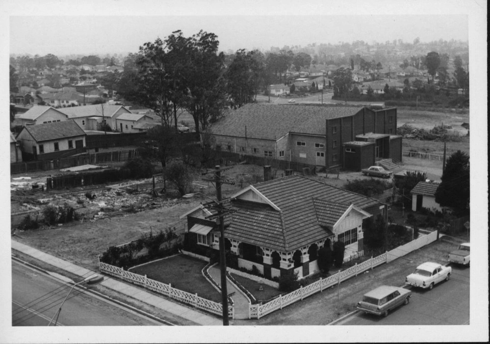
St Patrick's Cemetery was in the grounds of St Patrick's Church and Primary School, fronting Patrick Street, Blacktown. The main entrance of Westpoint shopping centre can be seen in the background. The land was sold in the early 1980s, and a shopping mall was built on the site. The church and school moved to Allawah Street, Blacktown. The headstones were also moved to that site. Photo: Blacktown City Libraries
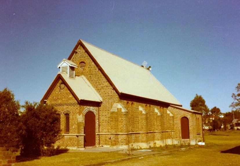
Image taken facing south of St Paul's Anglican Church at 19 Elizabeth Street in Riverstone. St Paul's church is one of the oldest buildings in Riverstone, with the foundation stone laid on 12 November 1884 by Mrs James Richards. The first service was held on 7 March 1885. In 2017 the church was renamed Life Anglican Church. In 2024 the church was again renamed New Light Anglican Church.
The Church is listed as a heritage item of local significance, according to the Blacktown Local Environment Plan (BLEP) of 1988 and 2015.Photo: Blacktown City Libraries
St Patrick's Cemetery was in the grounds of St Patrick's Church and Primary School, fronting Patrick Street, Blacktown. The main entrance of Westpoint shopping centre can be seen in the background. The land was sold in the early 1980s, and a shopping mall was built on the site. The church and school moved to Allawah Street, Blacktown. The headstones were also moved to that site. Photo: Blacktown City Libraries
Image taken facing south of St Paul's Anglican Church at 19 Elizabeth Street in Riverstone. St Paul's church is one of the oldest buildings in Riverstone, with the foundation stone laid on 12 November 1884 by Mrs James Richards. The first service was held on 7 March 1885. In 2017 the church was renamed Life Anglican Church. In 2024 the church was again renamed New Light Anglican Church.
The Church is listed as a heritage item of local significance, according to the Blacktown Local Environment Plan (BLEP) of 1988 and 2015.Photo: Blacktown City Libraries
Our love of shopping
Shopping in Blacktown has evolved from small family-run stores and local markets to major retail centres and bustling commercial precincts
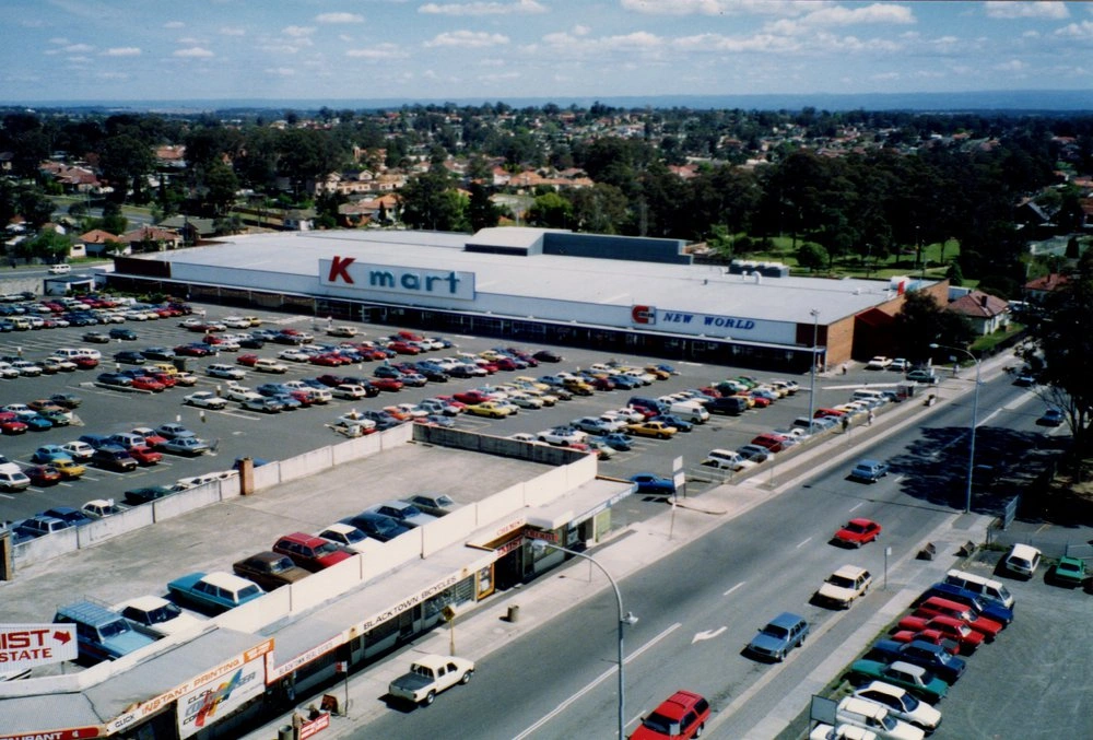
Elevated view of K-mart and Coles New World and the car park. Photo: Blacktown City Libraries
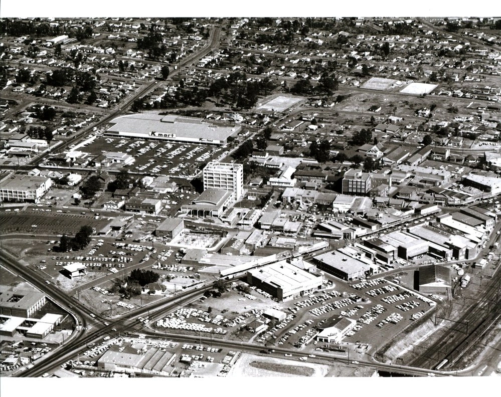
Aerial view of Blacktown CBD, taken before the construction of Blacktown Westpoint. Kmart, Tennis courts on Alpha Street and Balmoral Street can also be seen.
Photograph showing Mr Dale's residence on the corner of Flushcombe Road and Alpha Street. Also showing Masonic Temple prior to being demolished to make way for Kmart.
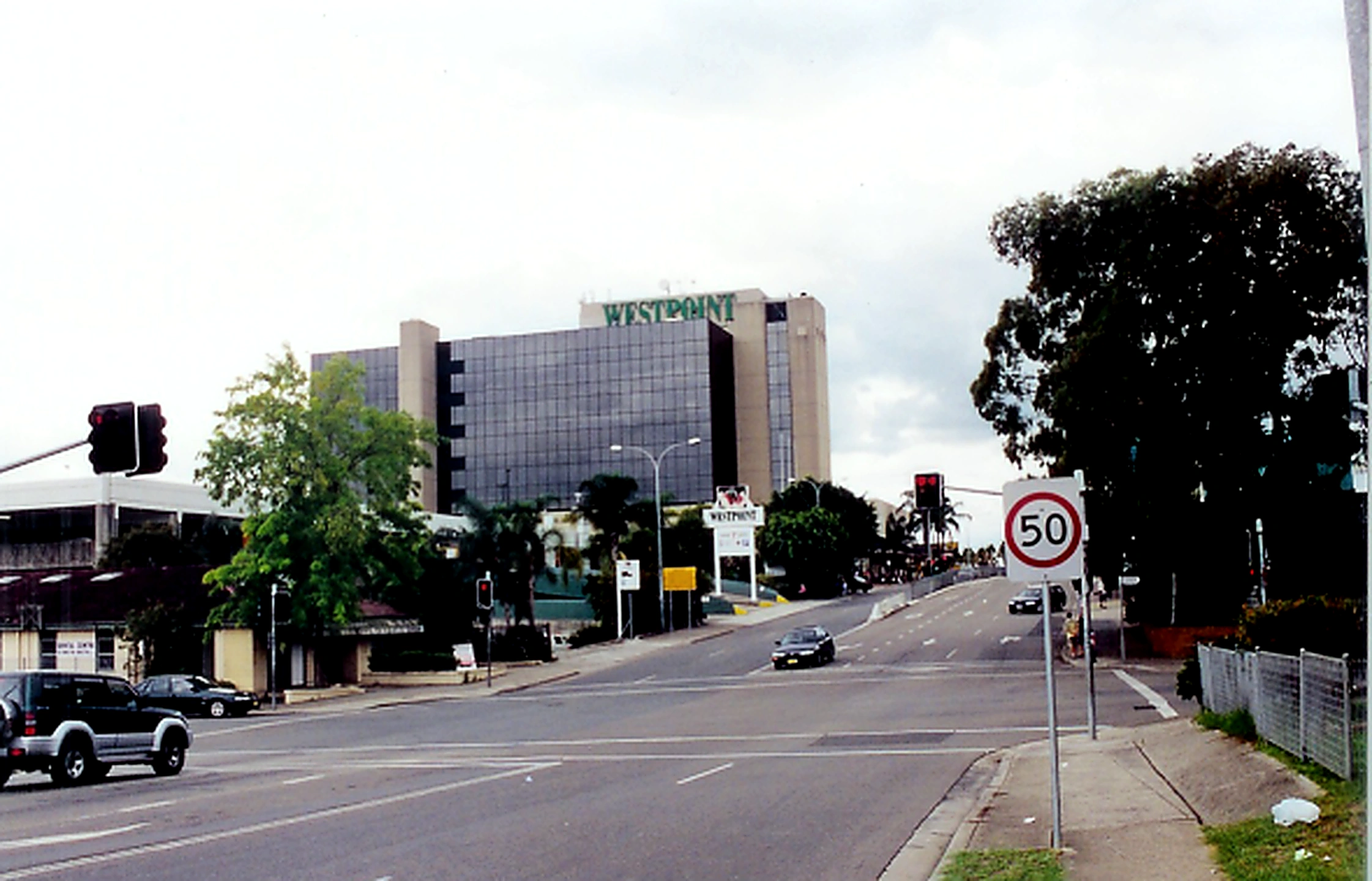
Patrick Street Blacktown showing Westpoint Blacktown
Elevated view of K-mart and Coles New World and the car park. Photo: Blacktown City Libraries
Aerial view of Blacktown CBD, taken before the construction of Blacktown Westpoint. Kmart, Tennis courts on Alpha Street and Balmoral Street can also be seen.
Photograph showing Mr Dale's residence on the corner of Flushcombe Road and Alpha Street. Also showing Masonic Temple prior to being demolished to make way for Kmart.
Patrick Street Blacktown showing Westpoint Blacktown
Parks and Gardens
Blacktown’s parks and gardens provide peaceful green spaces where families gather, children play and locals enjoy nature.
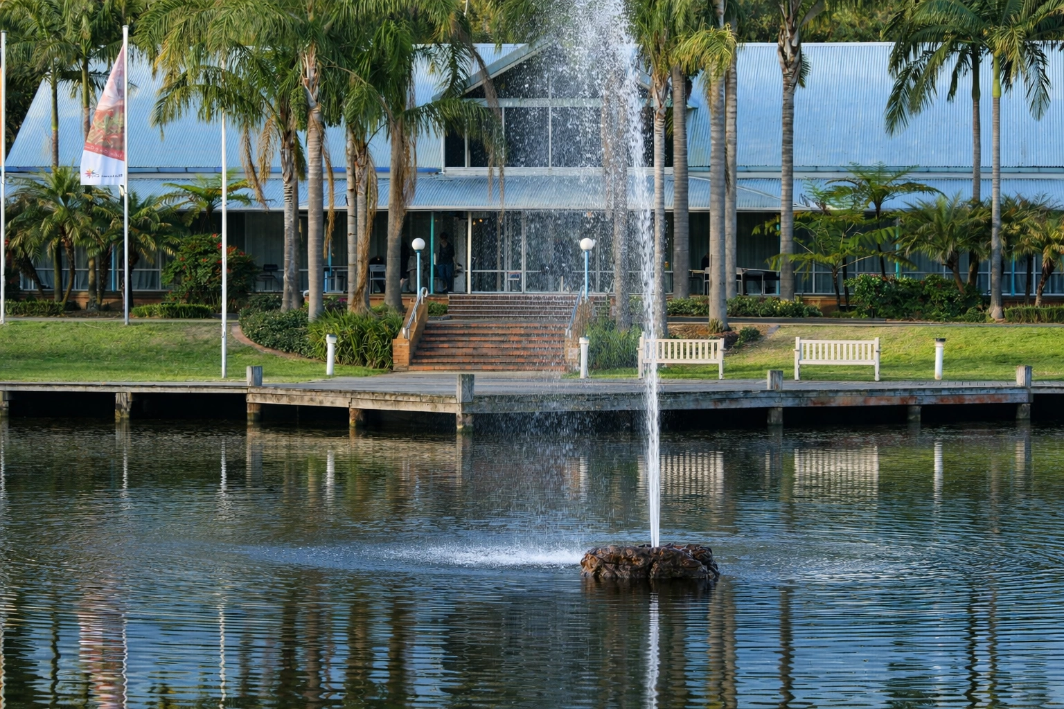
The Colbee Centre at Nurragingy with outdoor landscaped area and fountain
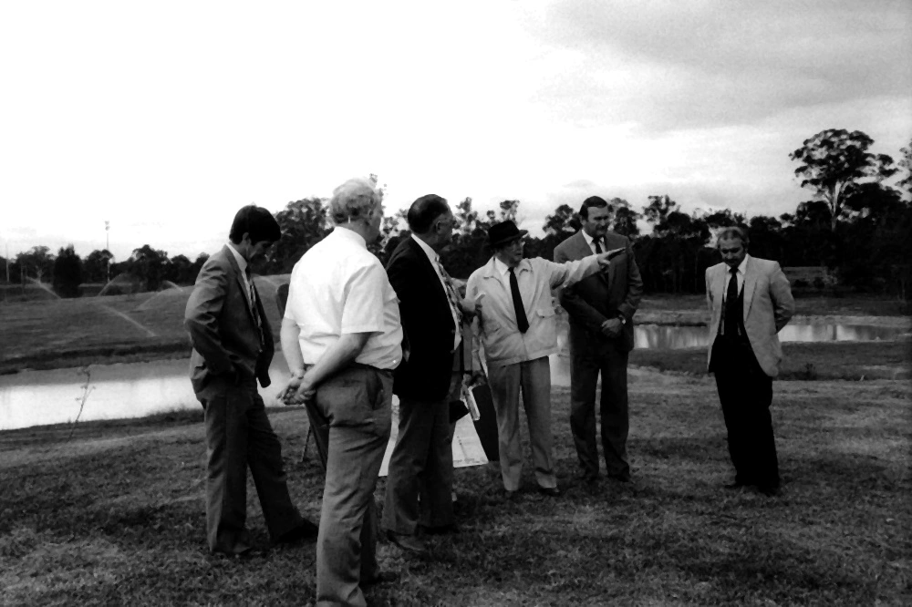
Official council delegation at Nurragingy Reserve prior to the redevelopment of the Reserve. The lake can be seen in the background.

Walking trail at Nurragingy Reserve, Doonside.
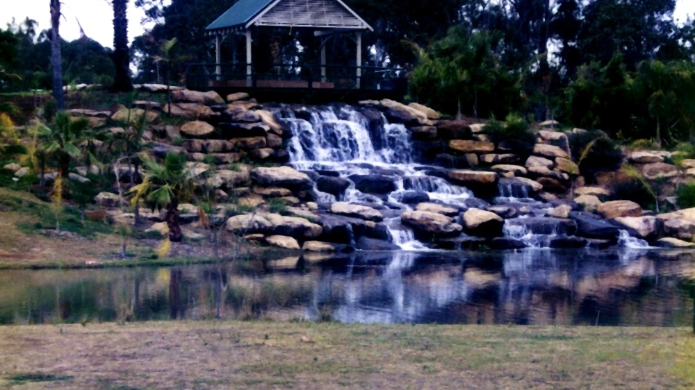
Landscaped park area with waterfall at Nurragingy Reserve, Doonside.
The Colbee Centre at Nurragingy with outdoor landscaped area and fountain
Official council delegation at Nurragingy Reserve prior to the redevelopment of the Reserve. The lake can be seen in the background.
Walking trail at Nurragingy Reserve, Doonside.
Landscaped park area with waterfall at Nurragingy Reserve, Doonside.
Our Love of Sport
Blacktown has a strong sporting spirit, with locals passionately playing and supporting everything from grassroots footy and cricket to elite competition.
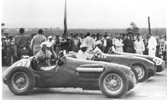
Mt Druitt Racetrack (formerly WWII RAAF Base) opened in 1948 as 2.9 km and was extended to 3.6km in 1952. Each race day attracted over 15,000 people. The last race was held in November 1957.
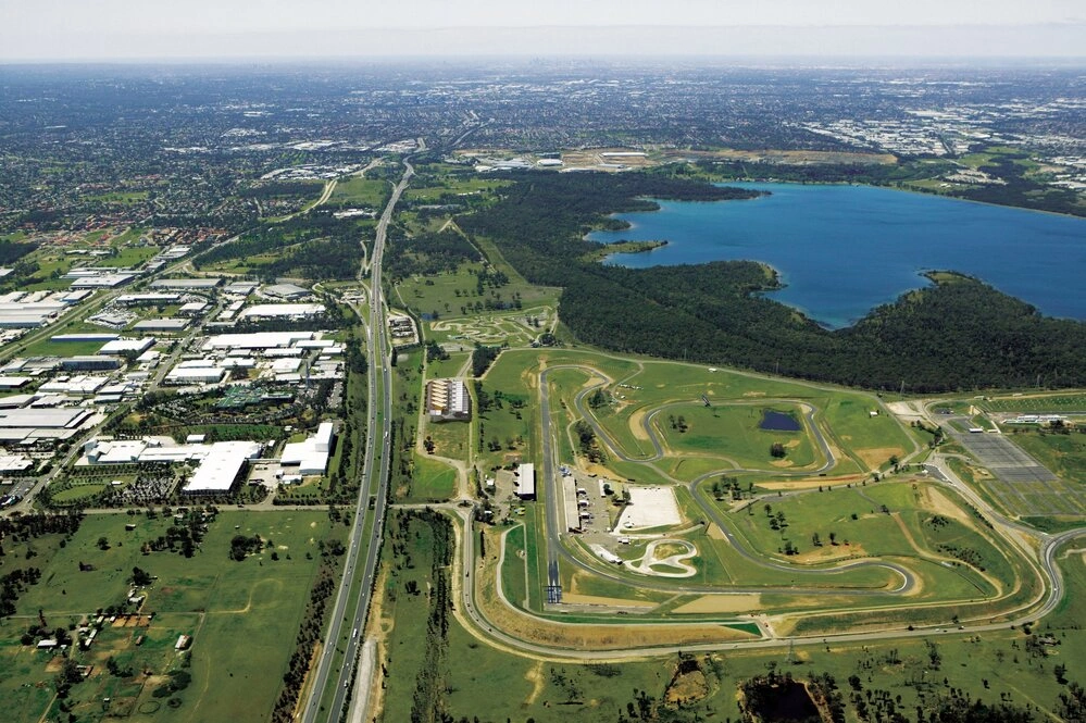
Aerial view of Prospect Reservoir and Eastern Creek raceway
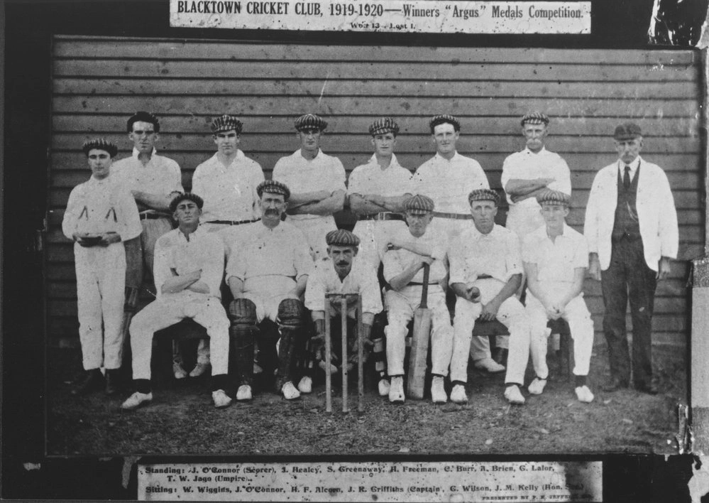
Blacktown Cricket Club, 1919-1920 after winning the Argus Competition. Standing, left to right: J O'Connor, Scorer; J Healey; S Greenaway; H Freeman; C Burr; A Brien; G Lalor; T W Jago, umpire. Sitting: W Wiggins; J O'Connor; H F Alcorn; G R Griffiths, Captain; G Wilson; J M Kelly, Hon Secretary. The medals were presented to the team at a function held at McKay's Ballroom Parramatta on Saturday 6 June 1920.
Mt Druitt Racetrack (formerly WWII RAAF Base) opened in 1948 as 2.9 km and was extended to 3.6km in 1952. Each race day attracted over 15,000 people. The last race was held in November 1957.
Aerial view of Prospect Reservoir and Eastern Creek raceway
Blacktown Cricket Club, 1919-1920 after winning the Argus Competition. Standing, left to right: J O'Connor, Scorer; J Healey; S Greenaway; H Freeman; C Burr; A Brien; G Lalor; T W Jago, umpire. Sitting: W Wiggins; J O'Connor; H F Alcorn; G R Griffiths, Captain; G Wilson; J M Kelly, Hon Secretary. The medals were presented to the team at a function held at McKay's Ballroom Parramatta on Saturday 6 June 1920.
Entertaining Blacktown
Entertaining Blacktown has always meant drive-ins and cinemas, live music, community fairs, sporting matches, theatre shows, markets and festivals
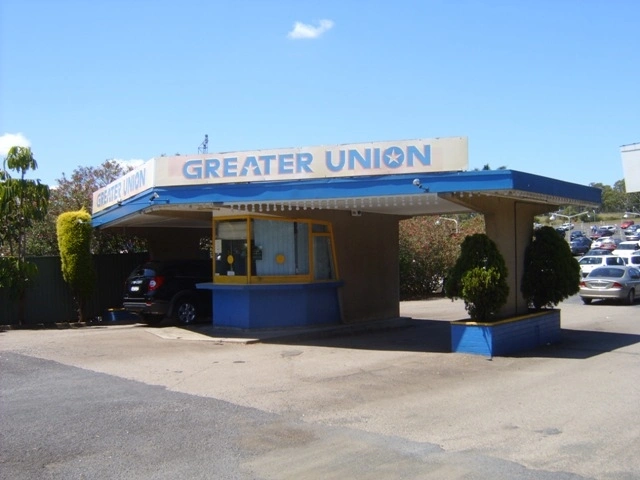
This photograph is of the entry and ticket gates of the Greater Union Drive-in Theatre, Blacktown. The Drive-in is located on Cricketers Arms Road, Prospect. Photo Les Tod
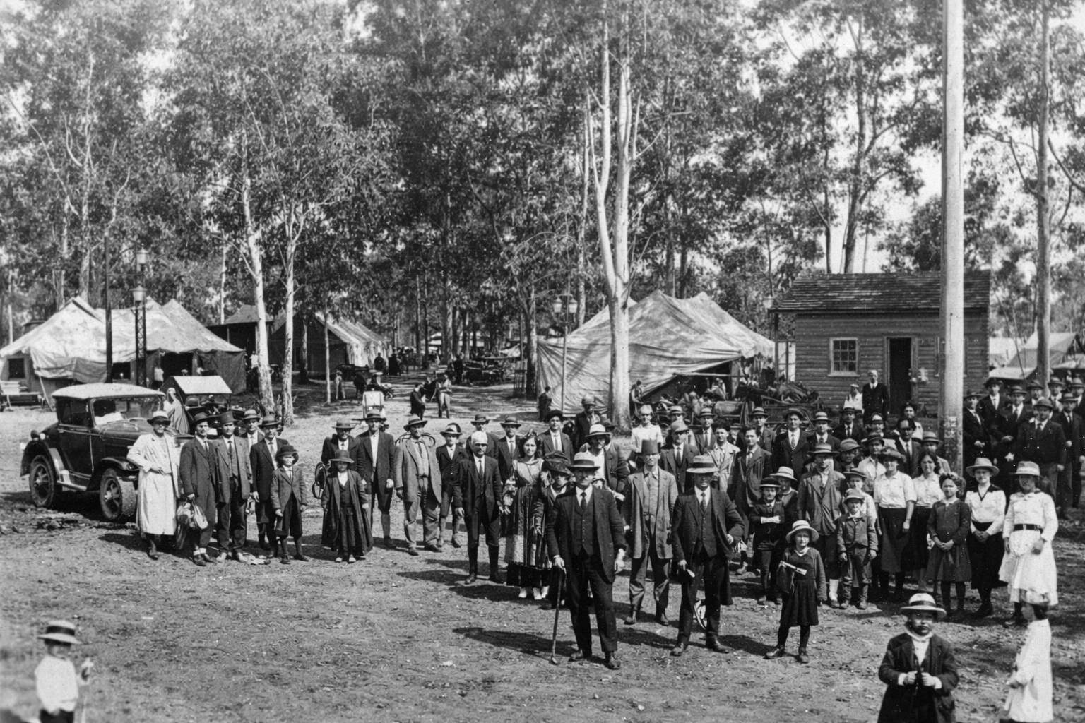
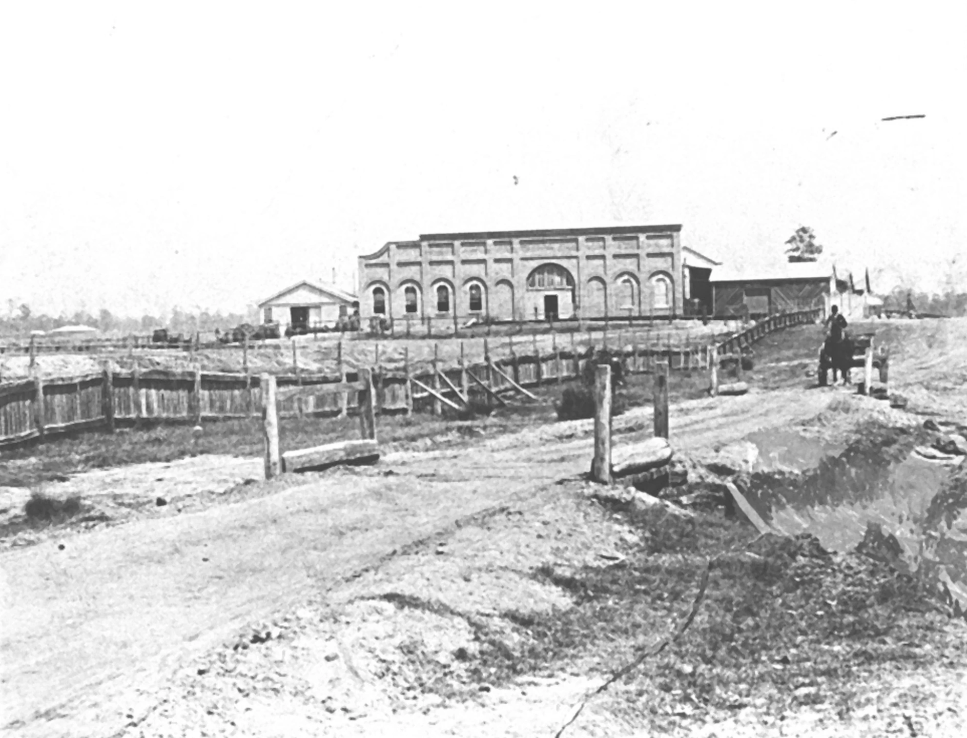
The Blacktown Agricultural Society's third Show was the first held in the Showground, on 3rd and 4th March 1922. The Show was opened by NSW Treasurer J.T. Lang (premier in later years) and was hailed a big success with over 5000 people attending. The photograph was taken on 3rd March 1922. Photo: Blacktown City Libraries
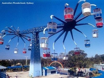
Australia's Wonderland
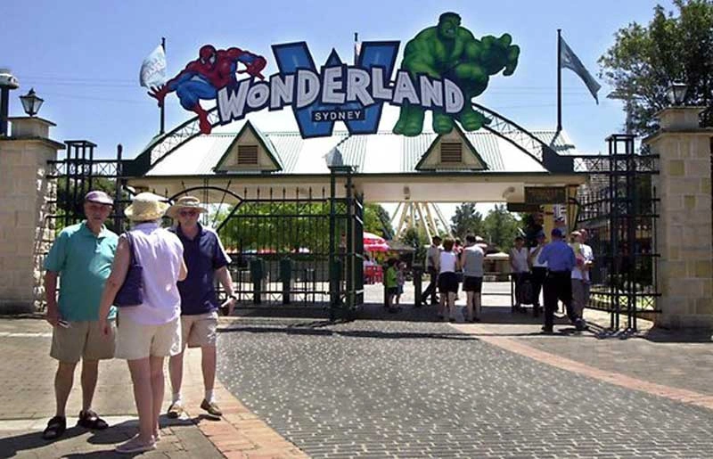
Australia's Wonderland
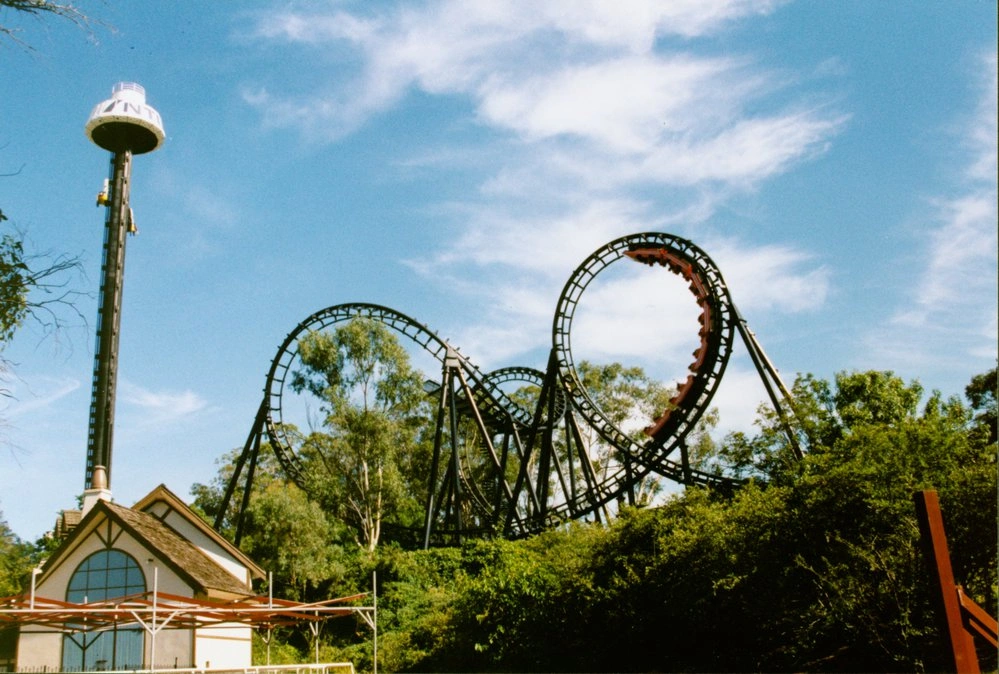
Australia's Wonderland
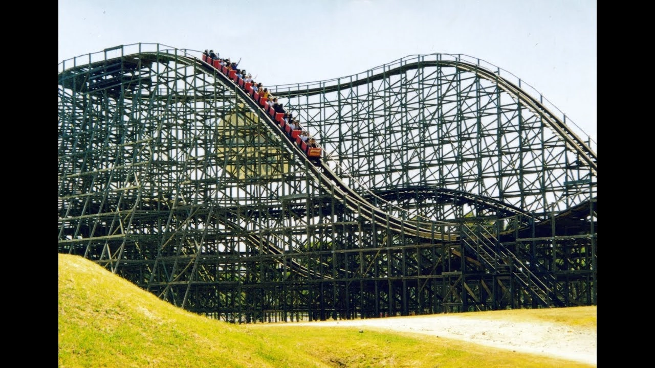
Australia's Wonderland
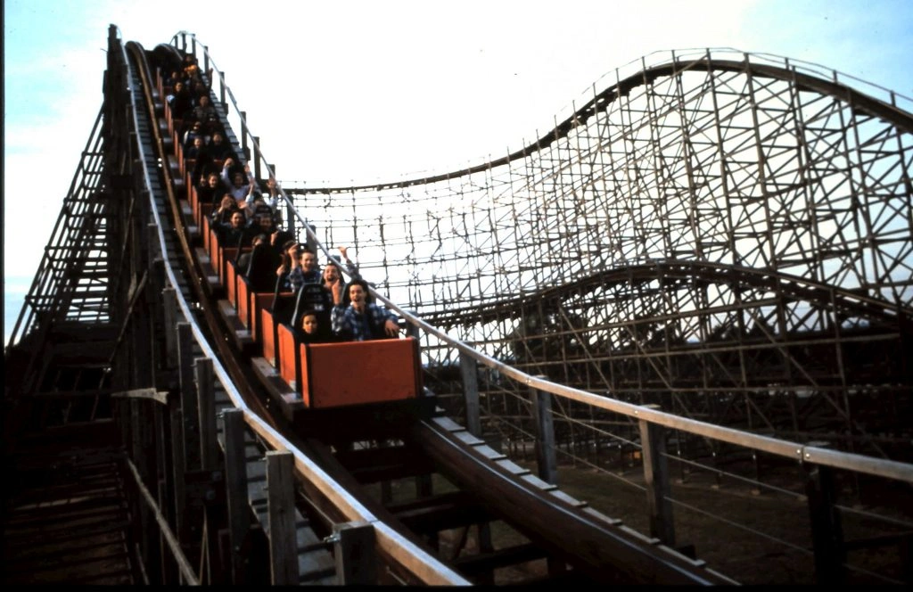
Australia's Wonderland
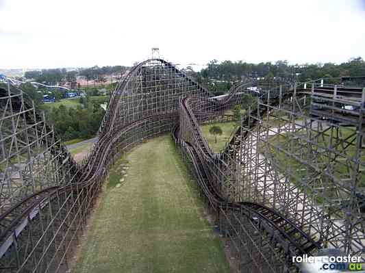
Australia's Wonderland
This photograph is of the entry and ticket gates of the Greater Union Drive-in Theatre, Blacktown. The Drive-in is located on Cricketers Arms Road, Prospect. Photo Les Tod
The Blacktown Agricultural Society's third Show was the first held in the Showground, on 3rd and 4th March 1922. The Show was opened by NSW Treasurer J.T. Lang (premier in later years) and was hailed a big success with over 5000 people attending. The photograph was taken on 3rd March 1922. Photo: Blacktown City Libraries
Australia's Wonderland
Australia's Wonderland
Australia's Wonderland
Australia's Wonderland
Australia's Wonderland
Australia's Wonderland
Our Festivals and Parades
Blacktown comes alive with its vibrant festivals and colourful parades, where community spirit shines through music, food, culture and celebration.
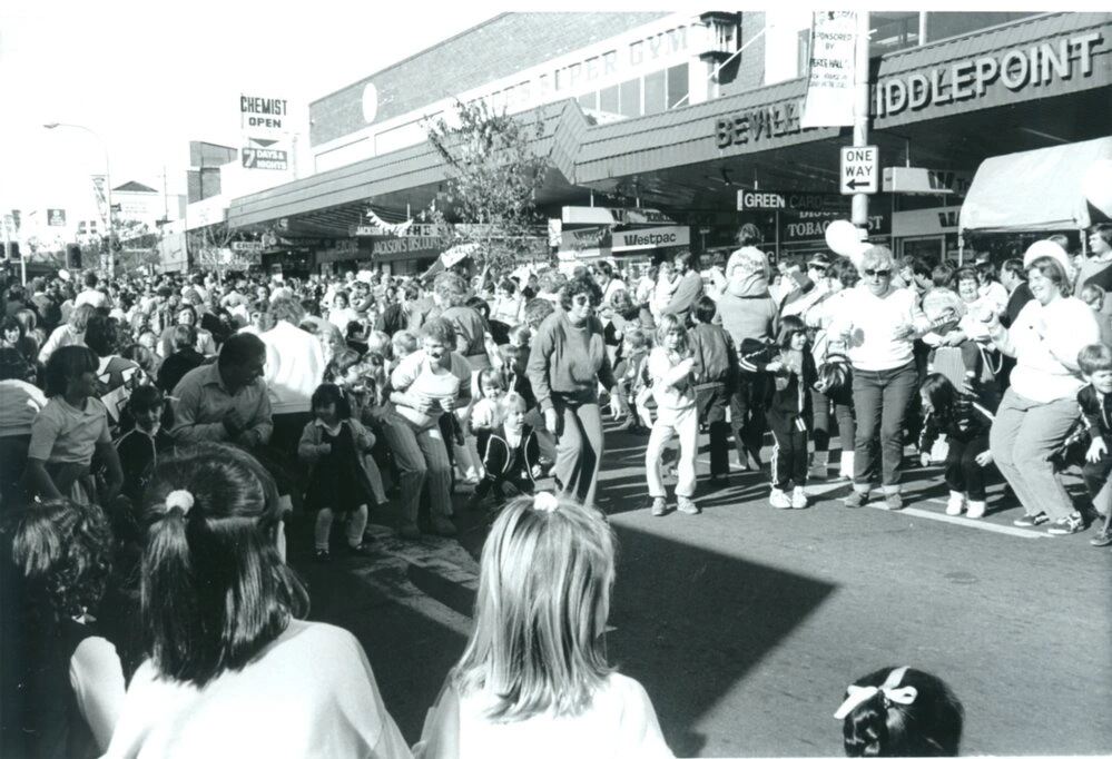
Parents joining in for the "Chicken Dance" in the street - Main Street between Flushcombe Road and Jim Simpson Lane.
Parents joining in for the "Chicken Dance" in the street - Main Street between Flushcombe Road and Jim Simpson Lane.
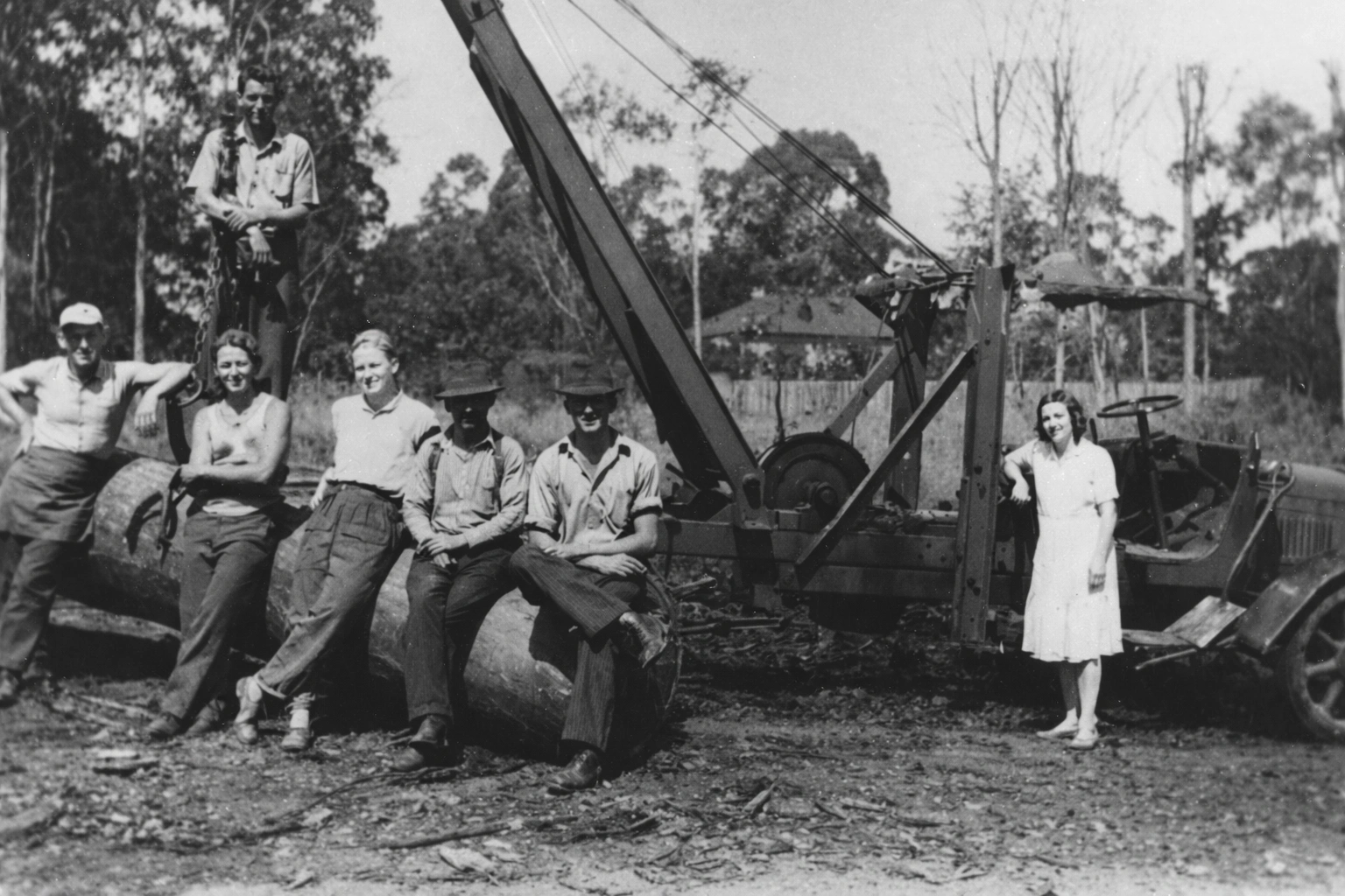
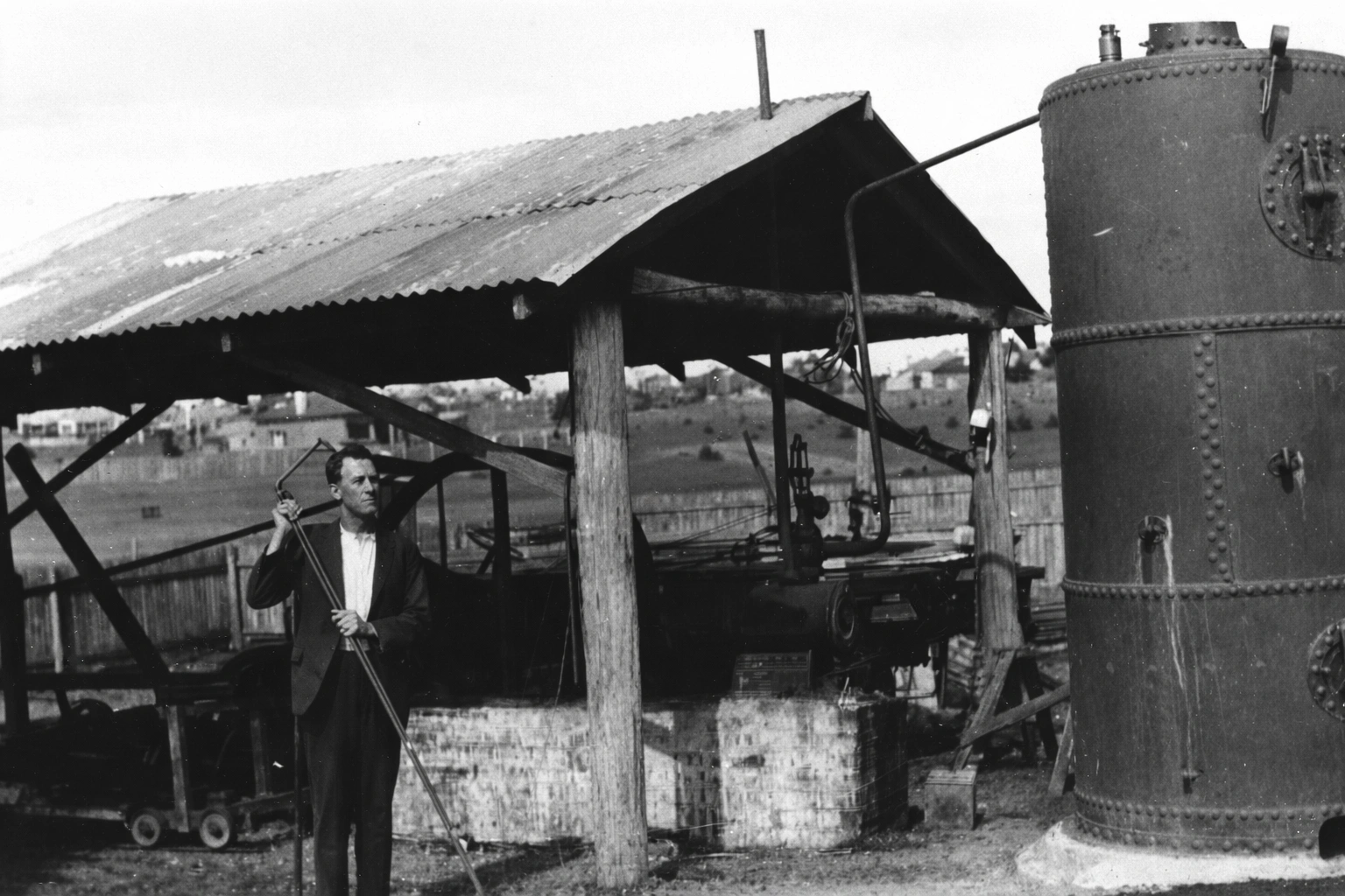
Industrial Blacktown
Industry in Blacktown has progressed from early farming and small-scale enterprises to a dynamic mix of manufacturing, logistics, and commercial hubs
Woodstock Fruit Cannery, Plumpton. It was located at what is now known as Cannery Rd and was founded in about 1887 by Walter Lamb of Woodstock Park, of which Lamb St, Plumpton, was also named. Photo: Blacktown City Libraries
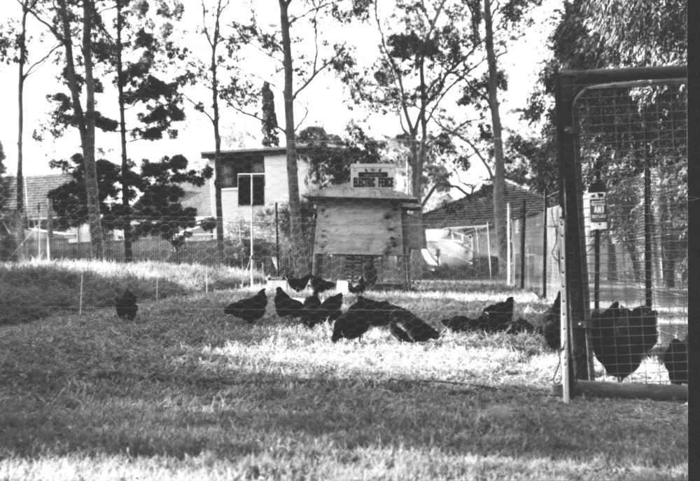
Photograph shows a chicken coop with hens pecking at the ground on the poultry site. The former Grantham Poultry Research Station located at Seven Hills, operated since 1912 as an experimental farm under the NSW Government. Over its history the farm has had many owner's and uses, it was also used for a Returned Soldiers Settlement 1917-23 providing housing and work for World War One soldiers. The research station was closed down in 1988 and large parts of the property was sold.
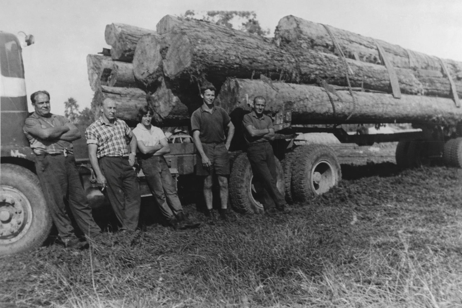
Michau's timber mill, founded in 1946, was located on Bungarribee Road, Blacktown. The timber mill was demolished in late 1984. Timber mill workers in this photograph.
Michau's timber mill, founded in 1946, was located on Bungarribee Road, Blacktown. The timber mill was demolished in late 1984.Michau's timber mill workers in this photograph.
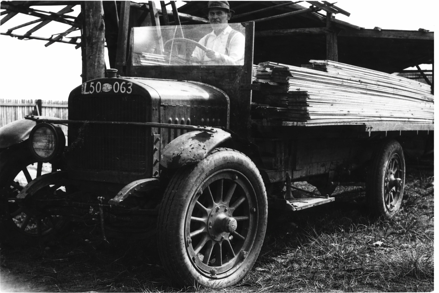
J. H. Couch's Western Timber Yard, George Street, Blacktown
J. H. Couch's Western Timber Yard, George Street, Blacktown
Woodstock Fruit Cannery, Plumpton. It was located at what is now known as Cannery Rd and was founded in about 1887 by Walter Lamb of Woodstock Park, of which Lamb St, Plumpton, was also named. Photo: Blacktown City Libraries
Photograph shows a chicken coop with hens pecking at the ground on the poultry site. The former Grantham Poultry Research Station located at Seven Hills, operated since 1912 as an experimental farm under the NSW Government. Over its history the farm has had many owner's and uses, it was also used for a Returned Soldiers Settlement 1917-23 providing housing and work for World War One soldiers. The research station was closed down in 1988 and large parts of the property was sold.
Michau's timber mill, founded in 1946, was located on Bungarribee Road, Blacktown. The timber mill was demolished in late 1984. Timber mill workers in this photograph.
Michau's timber mill, founded in 1946, was located on Bungarribee Road, Blacktown. The timber mill was demolished in late 1984.Michau's timber mill workers in this photograph.
J. H. Couch's Western Timber Yard, George Street, Blacktown
J. H. Couch's Western Timber Yard, George Street, Blacktown
Pubs and Clubs
The pubs and clubs of Blacktown have long been social heartbeats of the community, evolving from early colonial inns serving travellers and locals to vibrant modern venues.
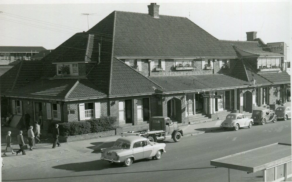
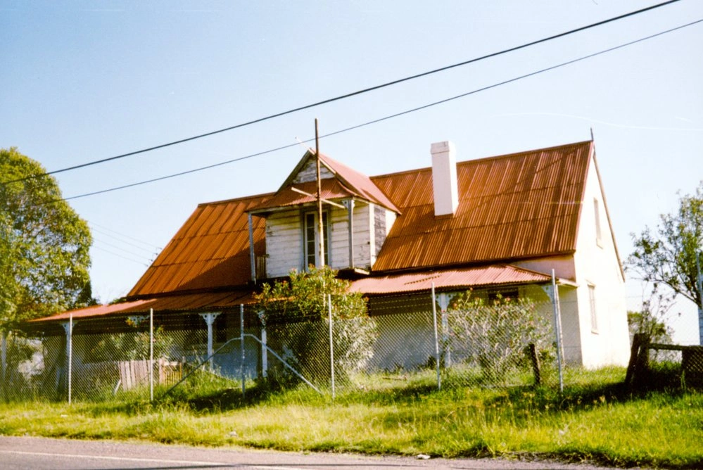
The Robin Hood Inn is one of Blacktown’s most significant surviving colonial buildings, dating back to the mid-19th century when the area was still developing along the old Western Road. Built in 1836 by John Schofield, the inn originally served travellers, teamsters and locals moving between Sydney and the expanding farming districts to the west. In those days, inns were more than pubs — they were vital social hubs, places to rest horses, exchange news and conduct business in a growing frontier community.
Over time, as transport routes changed and Blacktown modernised, the inn ceased operating as a hotel, but the building survived while many others disappeared. Today, the Robin Hood Inn stands as a rare reminder of early European settlement in the district, reflecting Blacktown’s transformation from rural outpost to thriving city. Its simple colonial architecture and long history make it an important landmark for anyone interested in the heritage story of Blacktown.
Robin Hood Inn, Blacktown
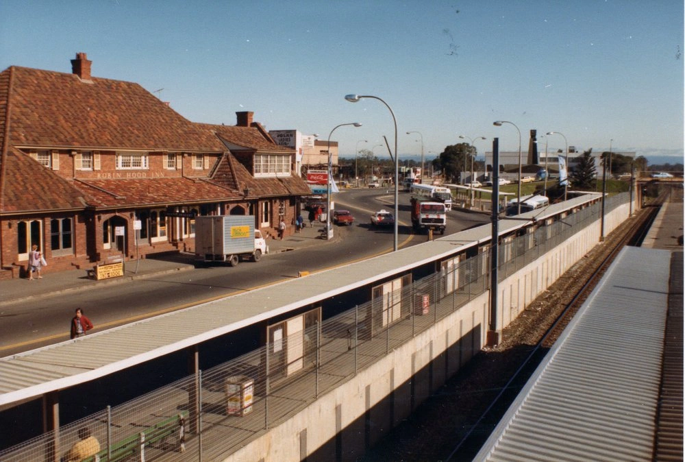
View of Main Street, Blacktown with the Robin Hood Inn on the left, Blacktown Court House and Clock Tower in the background just after the railway overpass. The Bus interchange and Blacktown Railway Station to the right. Photo: Blacktown City Libraries
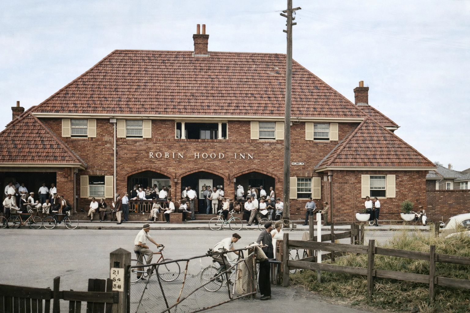
Robin Hood Inn situated in Main Street (previously Blacktown Road), Blacktown. It was demolished in 1984

The Royal Cricketer's Arms Hotel was built between 1876 and 1881 to serve travellers along the Western Road and the workers at the nearby Prospect Reservoir. James Manning was issued with the hotel's first Publican licence. Sarah Roche held the licence between 1895 and 1901, and there were then various licensees until 1911, when the building was used for other purposes.
Royal Cricketer's Arms Hotel, Reservoir Road, Prospect.
The Royal Cricketers Arms located on the southern boundary of the crown land grant to Captain Robert Lethbridge, Royal Navy, in June 1823. The Inn is believed to have been built in the late 1870's and was first operated by James Manning and Agnes Neeves in 1880. This photograph was taken before the Department of Urban Affairs restored the exterior in 1989. The site was then leased to James and Susan Kelly who restored the interior and re-opened the inn as an English-style pub in May 1994.
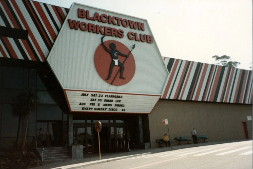
Started as an old tin shed on Kildare Road, Blacktown Workingman's Club was established in 1955. The name was soon changed to Blacktown Workers Club and in 1960 the club was moved in Campbell Street.This image showing the entrance to the club.
The Robin Hood Inn is one of Blacktown’s most significant surviving colonial buildings, dating back to the mid-19th century when the area was still developing along the old Western Road. Built in 1836 by John Schofield, the inn originally served travellers, teamsters and locals moving between Sydney and the expanding farming districts to the west. In those days, inns were more than pubs — they were vital social hubs, places to rest horses, exchange news and conduct business in a growing frontier community.
Over time, as transport routes changed and Blacktown modernised, the inn ceased operating as a hotel, but the building survived while many others disappeared. Today, the Robin Hood Inn stands as a rare reminder of early European settlement in the district, reflecting Blacktown’s transformation from rural outpost to thriving city. Its simple colonial architecture and long history make it an important landmark for anyone interested in the heritage story of Blacktown.
Robin Hood Inn, Blacktown
View of Main Street, Blacktown with the Robin Hood Inn on the left, Blacktown Court House and Clock Tower in the background just after the railway overpass. The Bus interchange and Blacktown Railway Station to the right. Photo: Blacktown City Libraries
Robin Hood Inn situated in Main Street (previously Blacktown Road), Blacktown. It was demolished in 1984
The Royal Cricketer's Arms Hotel was built between 1876 and 1881 to serve travellers along the Western Road and the workers at the nearby Prospect Reservoir. James Manning was issued with the hotel's first Publican licence. Sarah Roche held the licence between 1895 and 1901, and there were then various licensees until 1911, when the building was used for other purposes.
Royal Cricketer's Arms Hotel, Reservoir Road, Prospect.
The Royal Cricketers Arms located on the southern boundary of the crown land grant to Captain Robert Lethbridge, Royal Navy, in June 1823. The Inn is believed to have been built in the late 1870's and was first operated by James Manning and Agnes Neeves in 1880. This photograph was taken before the Department of Urban Affairs restored the exterior in 1989. The site was then leased to James and Susan Kelly who restored the interior and re-opened the inn as an English-style pub in May 1994.
Started as an old tin shed on Kildare Road, Blacktown Workingman's Club was established in 1955. The name was soon changed to Blacktown Workers Club and in 1960 the club was moved in Campbell Street.This image showing the entrance to the club.

Our Changing Landscape
Blacktown has evolved from open farmland and market gardens into a thriving, densely developed urban centre.
Bidwill once looked out across stretches of market gardens, with Shalvey visible on the horizon — an area formerly known as Plumpton around 1965 — reflecting a time when the district was still largely rural before its gradual transition into the suburban communities we know today.
Bidwill once looked out across stretches of market gardens, with Shalvey visible on the horizon — an area formerly known as Plumpton around 1965 — reflecting a time when the district was still largely rural before its gradual transition into the suburban communities we know today.
Blacktown and District - For Sale
Early land sales in Blacktown gradually transformed rural farmland into residential suburbs.
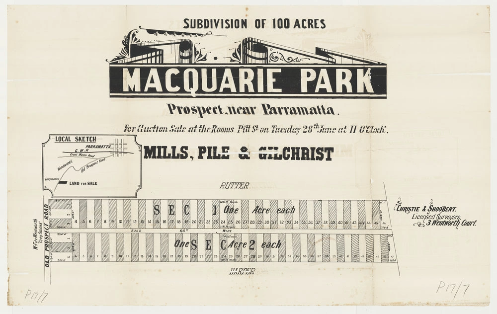
Macquarie Park, Prospect near Parramatta. For auction sale at the rooms Pitt Street on Tuesday 28 June (?1892). Mulls, Pile & Gilchrist. Christie & Shoobert, Licensed Surveyors, 3 Wentworth Court. The map shows the Old Prospect Road, W. FitzWentworth "Greystanes", Harper, Rutter and a location map.The subdivision map shows the subdivision of 100 acres at Macquarie Park, Prospect. The subdivision probably takes its name from Charles Whalan's property "Macquarie Park" at Prospect. Although the subdivision map is undated, it is after 1890 when Francis Jenkins applied for certificates of indefensible land for Sections 1 and 2 of the Macquarie Park Estate.Section 1 contained 46 one acre blocks while section 2 contained 47 two acre blocks.
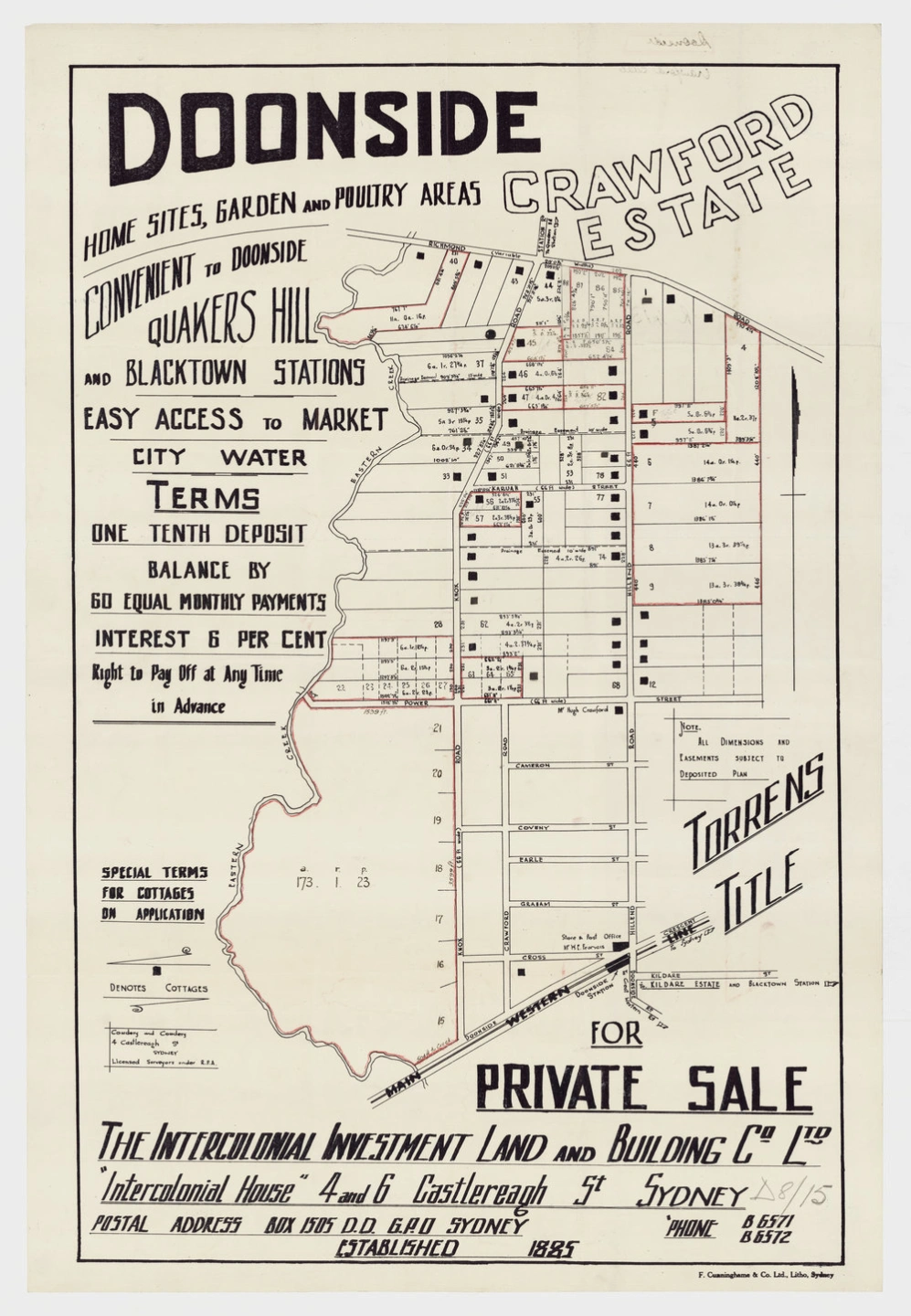
For private sale by the Intercolonial Investment Land and Building Company Limited. Home sites, gardens and poultry areas convenient to Doonside, Quakers Hill and Blacktown stations. Easy access to market by good roads. Torrens title. Terms 5 percent deposit, balance by 60 equal monthly payments, interest 6 percent. Homes built for buyers. Buyers assisted to build.The sale included land bounding Eastern Creek, Richmond Road, Hillend Road and Power Street. This map. Hugh Crawford's house, on the corner of Power Street and Hillend Road is shown. The map shows selected blocks for purchase (highlighted in red).
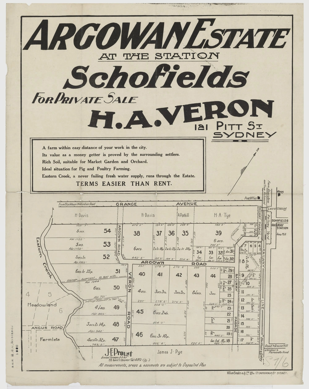
Argowan Estate at the station, Schofields. For private sale by H. A. Veron, 121 Pitt Street, Sydney. A farm within easy distance of your work in the city. Rich soil suitable for market garden and orchard. Ideal situation for pig and poultry family. Eastern Creek, a never failing fresh water supply, runs through the estate. J. E. Proust, Licensed Surveyot, 28 Bond Street Sydney. All measurements, areas & easements are subject to the deposited plan. The maps includes local landmarks including the Schofields railway station, post office, stores, and saw mill. Land belonging to James J Pye, H Davis, A Parkill and H A Tye is also marked.
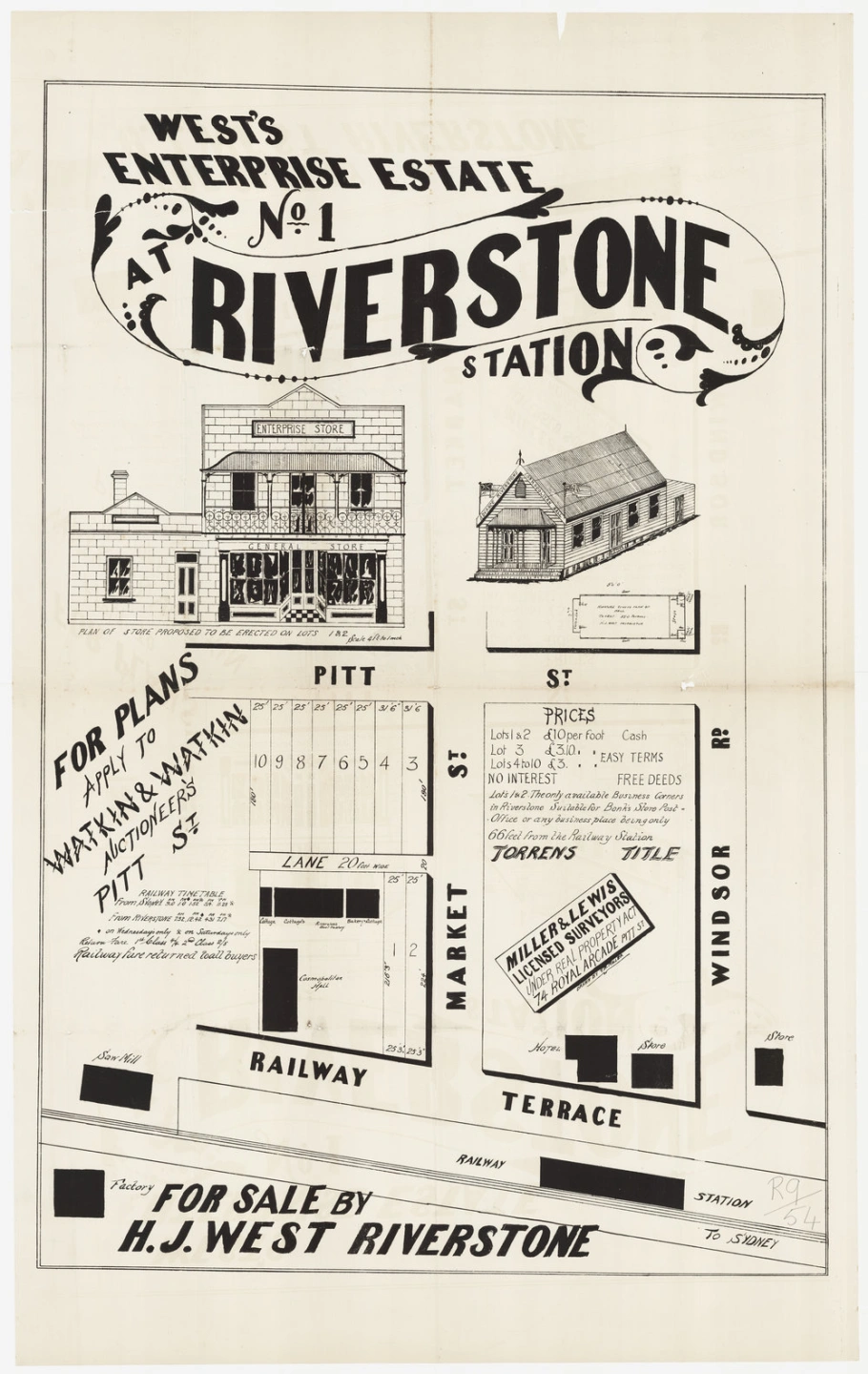
West's Enterprise Estate No 1 at Riverstone station. Prices. Lots 1 & 2 £10 per foot cash, Lot 3 £3.10 per foot easy terms, Lots 4-10 £3 per foot,east terms. Lots 1 and 2 the only available business corners in Riverstone. Suitable for banks, store, port office or any other business place being only 66 feet from the railway station. For plans apply to Watkin & Watkin, Auctioneers, Pitt Street. Miller and Lewis, Licensed Surveyors, 74 Royal Arcade, Pitt Street. The map contained a plan of the store proposed to be erected on Lots 1 & 2. A number of buildings including stores, Cosmopolitan Hall, Hotel, saw mill, Riverstone boot factory and bakery are included on the map. A railway timetable is also included.
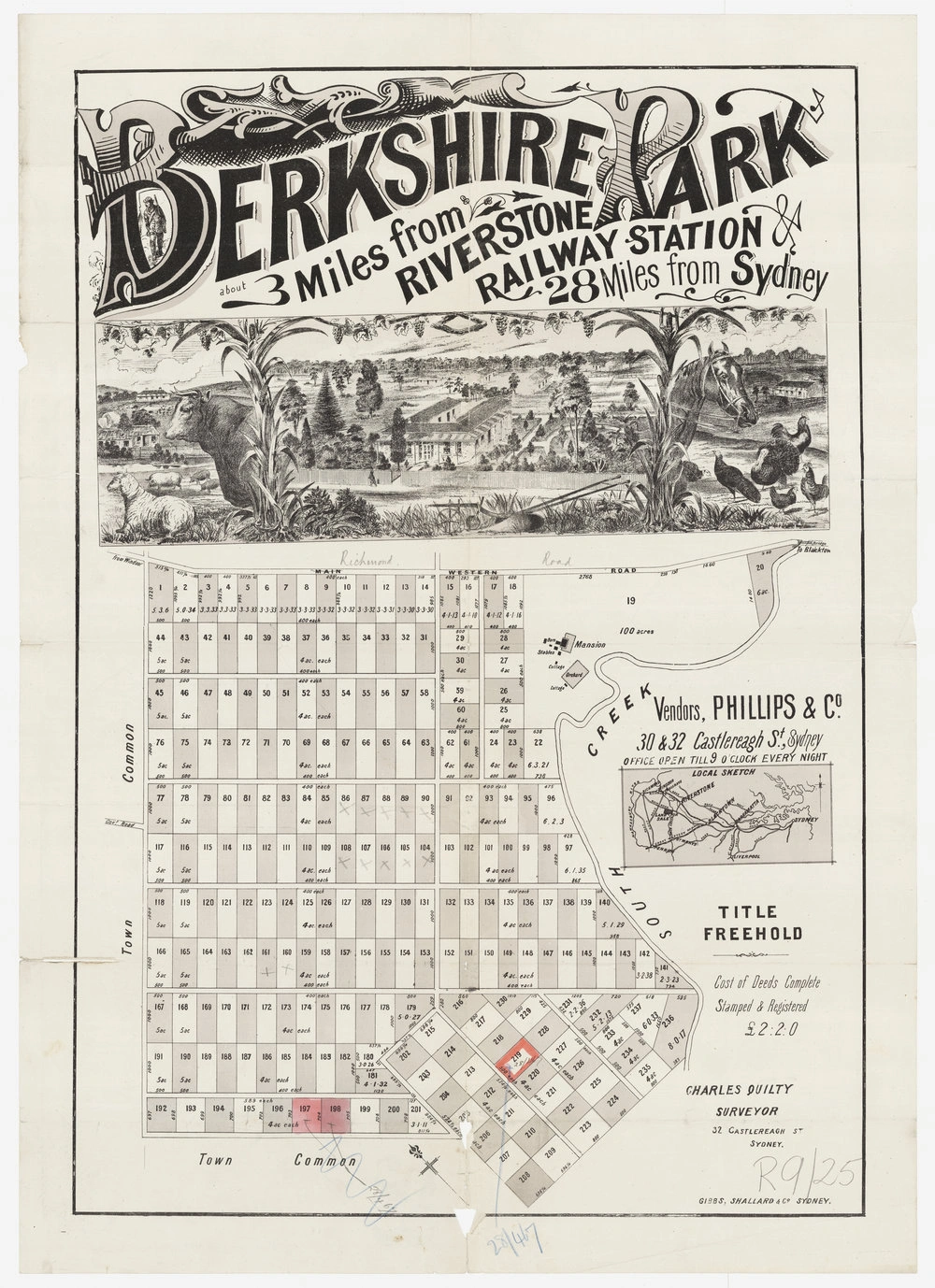
Berkshire Park, about 3 miles from Riverstone railway station. 28 miles from Sydney. The blocks located on Richmond Road, were close to South Creek and the town common.The four acre blocks were £60. Deposit of £5 and £2 per month, no interest. Freehold title. Vendors Phillips & Co, 30 & 32 Castlereagh St, Sydney. Charles Quilty, Surveyor 32 Castlereagh Street Sydney. The map includes a local sketch which shows the general location of the estate. The mansion, shown on the map, is Clydesdale.
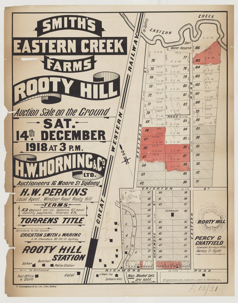
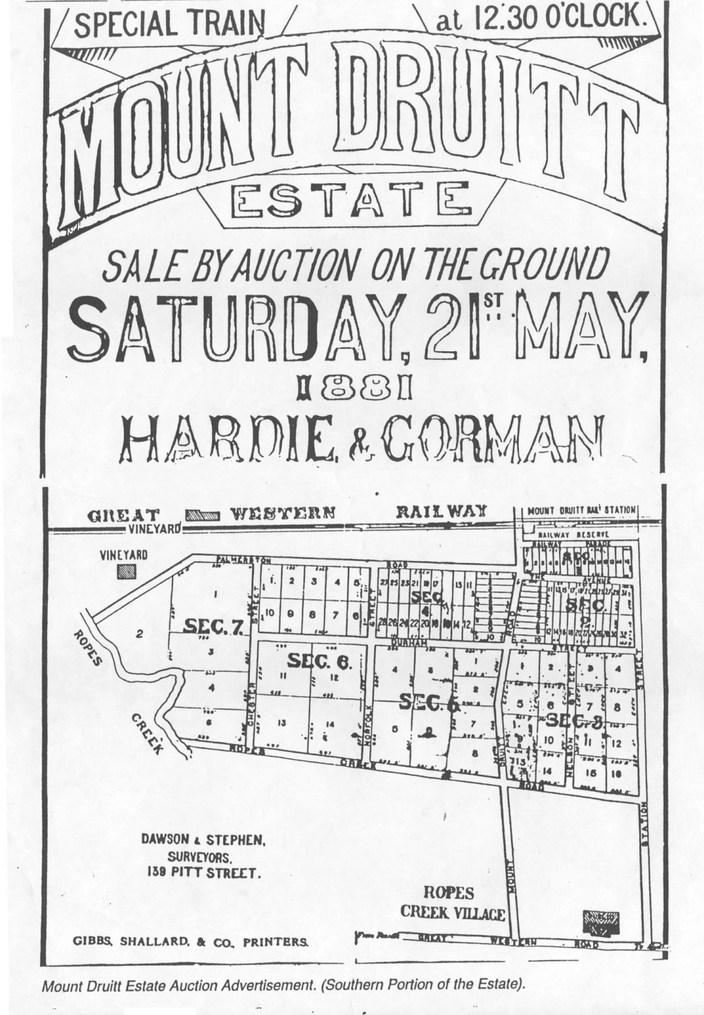
Smith's Eastern Creek Farms at Rooty Hill. Auction sale on the ground Saturday 14 December 1918 at 3 pm. H. W. Horning & Co. Ltd, auctioneers, 16 Moore Street Sydney. H. W. Perkins, local agent, Rooty Hill. Solicitors to the estate Crichton Smith & Waring, A. M. Chambers 89 Pitt Street Sydney. . Percy C. Chatfield, licensed surveyor, Parkes Street Ryde. £2 deposit per lot, balance 60 equal monthly payments. Interest 6%. Streets include Mavis Stree, Crichton Street, Richmond Road, Eastern Road, Dunsmore Street and Reginald Street. The map also includes local landmarks including the Imperial Hotel, James Angus' house, the Rooty Hill School of Arts and police station.Note - See two more similar maps and one information sheet attached as well.
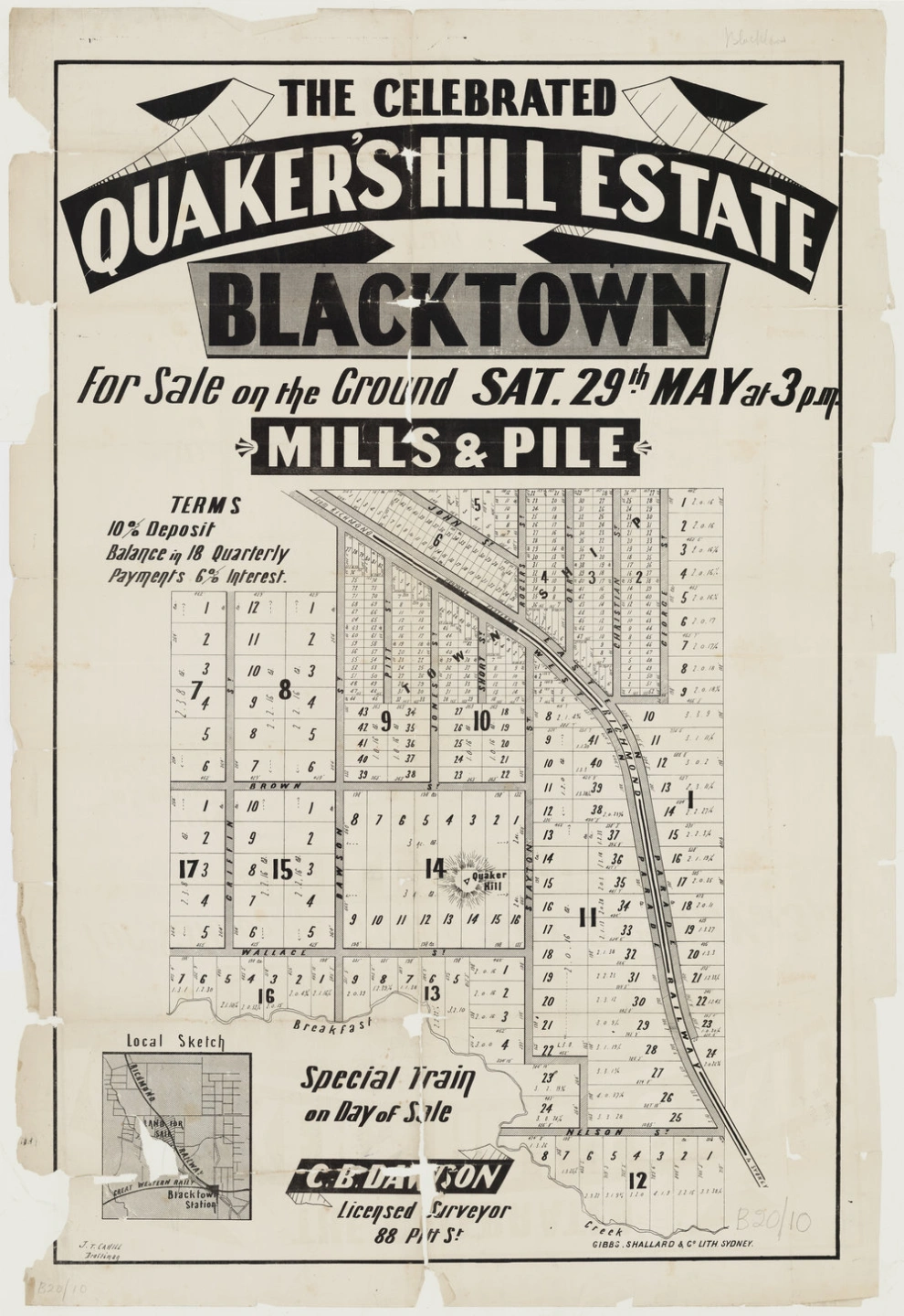
Lots along Richmond Railway line in Quakers Hill for sale on the ground Saturday 29th May at 3pm by Mills & Pile. C.B. Davison as licensed surveyor and J.T. Cahill as draftsman. Special train on the day of the sale. Quaker Hill property is also marked on the map.Another Smiliar map attached as well advertising sale on 12 June at 3pm.
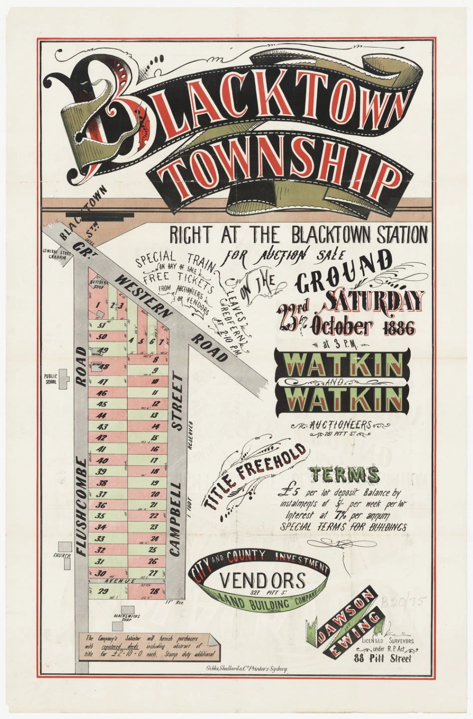
Lots right at Blacktown Station along Flushcombe Road, Campbell Street and Great Western Road (Main Street) for auction sale on the ground on Saturday 23rd October 1886 at 3pm by Watkin and Watkin (Auctioneers). Dawson Ewing as licensed surveyors. City and Country Investment, Land Building Company as vendors.The map also shows the location of cottages, the public school, church and blacksmith's shop.
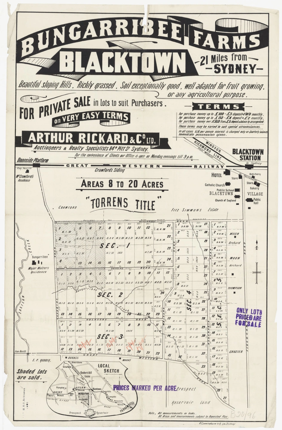
Areas 8 to 20 acres situated between Great Western Road and Bungarribee Road along Doonside Road, Douglas Road, Holbeche Road, Walters Road and Reservoir Road for private sale by Arthur Rickard & Co. Ltd. (Auctioneers)."Bungarribee" Major Walter's residence, Moon Orchard, Thompson, Crozier and other land owners are also marked on the map.
Macquarie Park, Prospect near Parramatta. For auction sale at the rooms Pitt Street on Tuesday 28 June (?1892). Mulls, Pile & Gilchrist. Christie & Shoobert, Licensed Surveyors, 3 Wentworth Court. The map shows the Old Prospect Road, W. FitzWentworth "Greystanes", Harper, Rutter and a location map.The subdivision map shows the subdivision of 100 acres at Macquarie Park, Prospect. The subdivision probably takes its name from Charles Whalan's property "Macquarie Park" at Prospect. Although the subdivision map is undated, it is after 1890 when Francis Jenkins applied for certificates of indefensible land for Sections 1 and 2 of the Macquarie Park Estate.Section 1 contained 46 one acre blocks while section 2 contained 47 two acre blocks.
For private sale by the Intercolonial Investment Land and Building Company Limited. Home sites, gardens and poultry areas convenient to Doonside, Quakers Hill and Blacktown stations. Easy access to market by good roads. Torrens title. Terms 5 percent deposit, balance by 60 equal monthly payments, interest 6 percent. Homes built for buyers. Buyers assisted to build.The sale included land bounding Eastern Creek, Richmond Road, Hillend Road and Power Street. This map. Hugh Crawford's house, on the corner of Power Street and Hillend Road is shown. The map shows selected blocks for purchase (highlighted in red).
Argowan Estate at the station, Schofields. For private sale by H. A. Veron, 121 Pitt Street, Sydney. A farm within easy distance of your work in the city. Rich soil suitable for market garden and orchard. Ideal situation for pig and poultry family. Eastern Creek, a never failing fresh water supply, runs through the estate. J. E. Proust, Licensed Surveyot, 28 Bond Street Sydney. All measurements, areas & easements are subject to the deposited plan. The maps includes local landmarks including the Schofields railway station, post office, stores, and saw mill. Land belonging to James J Pye, H Davis, A Parkill and H A Tye is also marked.
West's Enterprise Estate No 1 at Riverstone station. Prices. Lots 1 & 2 £10 per foot cash, Lot 3 £3.10 per foot easy terms, Lots 4-10 £3 per foot,east terms. Lots 1 and 2 the only available business corners in Riverstone. Suitable for banks, store, port office or any other business place being only 66 feet from the railway station. For plans apply to Watkin & Watkin, Auctioneers, Pitt Street. Miller and Lewis, Licensed Surveyors, 74 Royal Arcade, Pitt Street. The map contained a plan of the store proposed to be erected on Lots 1 & 2. A number of buildings including stores, Cosmopolitan Hall, Hotel, saw mill, Riverstone boot factory and bakery are included on the map. A railway timetable is also included.
Berkshire Park, about 3 miles from Riverstone railway station. 28 miles from Sydney. The blocks located on Richmond Road, were close to South Creek and the town common.The four acre blocks were £60. Deposit of £5 and £2 per month, no interest. Freehold title. Vendors Phillips & Co, 30 & 32 Castlereagh St, Sydney. Charles Quilty, Surveyor 32 Castlereagh Street Sydney. The map includes a local sketch which shows the general location of the estate. The mansion, shown on the map, is Clydesdale.
Smith's Eastern Creek Farms at Rooty Hill. Auction sale on the ground Saturday 14 December 1918 at 3 pm. H. W. Horning & Co. Ltd, auctioneers, 16 Moore Street Sydney. H. W. Perkins, local agent, Rooty Hill. Solicitors to the estate Crichton Smith & Waring, A. M. Chambers 89 Pitt Street Sydney. . Percy C. Chatfield, licensed surveyor, Parkes Street Ryde. £2 deposit per lot, balance 60 equal monthly payments. Interest 6%. Streets include Mavis Stree, Crichton Street, Richmond Road, Eastern Road, Dunsmore Street and Reginald Street. The map also includes local landmarks including the Imperial Hotel, James Angus' house, the Rooty Hill School of Arts and police station.Note - See two more similar maps and one information sheet attached as well.
Lots along Richmond Railway line in Quakers Hill for sale on the ground Saturday 29th May at 3pm by Mills & Pile. C.B. Davison as licensed surveyor and J.T. Cahill as draftsman. Special train on the day of the sale. Quaker Hill property is also marked on the map.Another Smiliar map attached as well advertising sale on 12 June at 3pm.
Lots right at Blacktown Station along Flushcombe Road, Campbell Street and Great Western Road (Main Street) for auction sale on the ground on Saturday 23rd October 1886 at 3pm by Watkin and Watkin (Auctioneers). Dawson Ewing as licensed surveyors. City and Country Investment, Land Building Company as vendors.The map also shows the location of cottages, the public school, church and blacksmith's shop.
Areas 8 to 20 acres situated between Great Western Road and Bungarribee Road along Doonside Road, Douglas Road, Holbeche Road, Walters Road and Reservoir Road for private sale by Arthur Rickard & Co. Ltd. (Auctioneers)."Bungarribee" Major Walter's residence, Moon Orchard, Thompson, Crozier and other land owners are also marked on the map.
Early Maps
Early maps of Blacktown show a rural farming district slowly evolving into a surveyed suburban community.
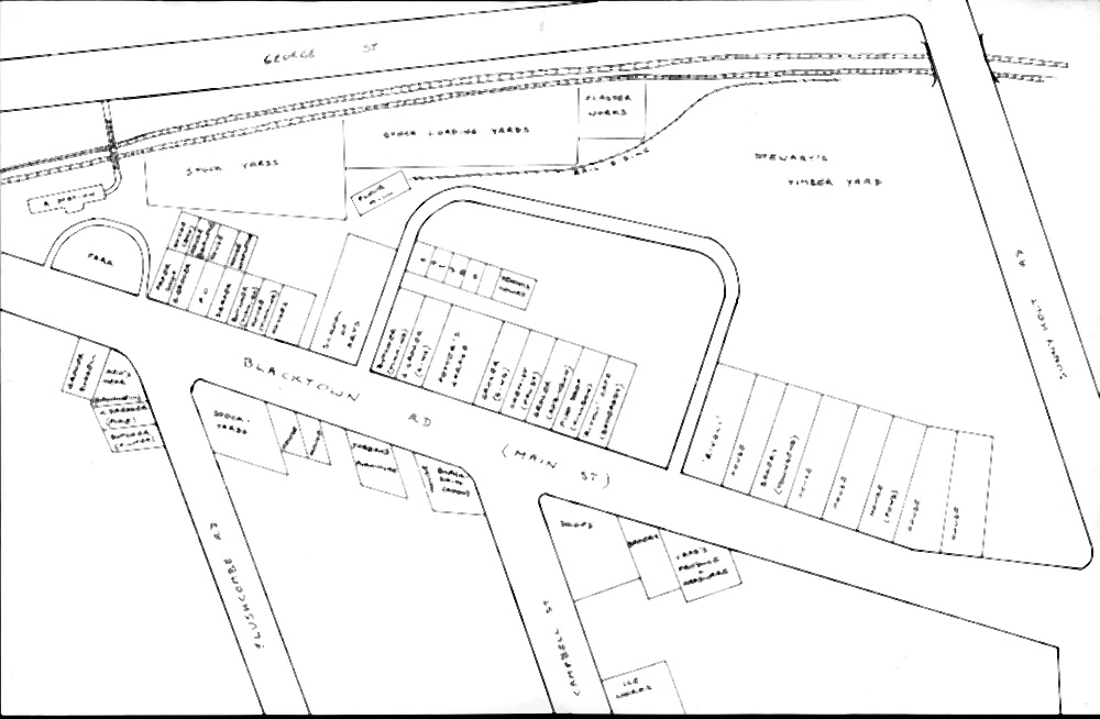
The hand drawn map by Jim Filmer and Jim Simpson shows the location of businesses located along Main Street, Blacktown.
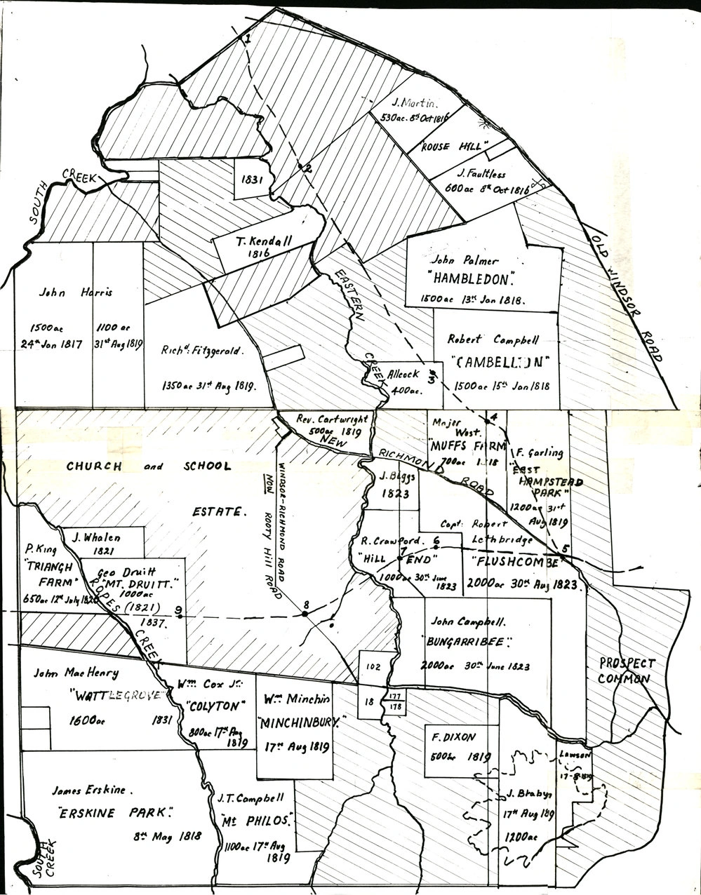
This hand drawn map provides details of the early land grants in the Blacktown City local government area. It also includes major waterways and main roads.Details of land grants should also be checked on the official parish maps.
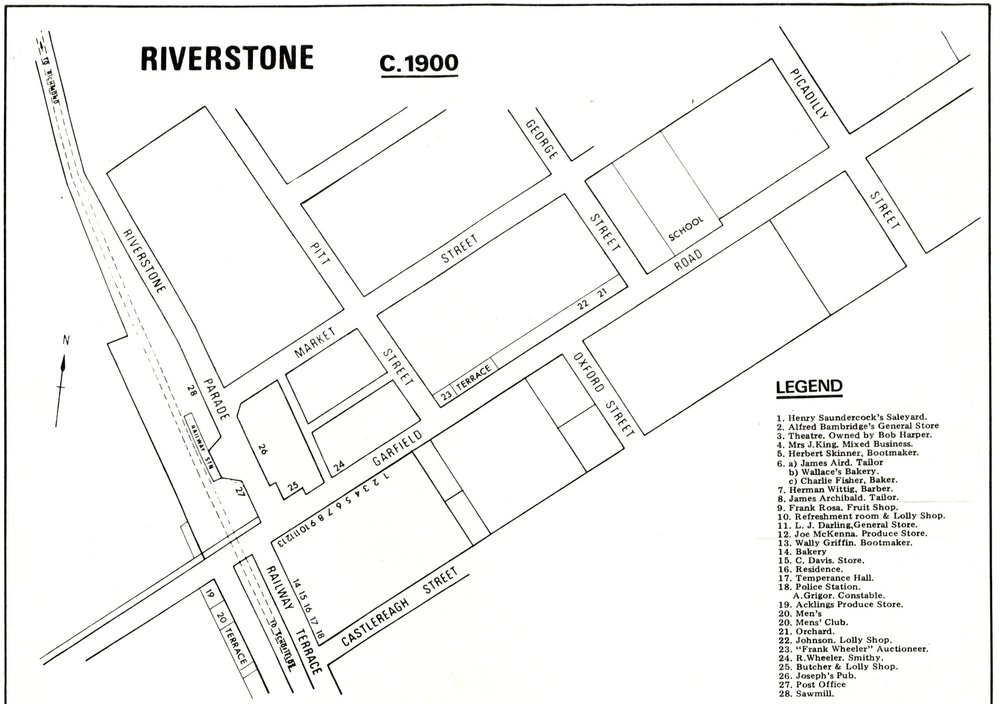
The map of Riverstone, from around 1900, shows the layout of the town and lists key businesses.
The hand drawn map by Jim Filmer and Jim Simpson shows the location of businesses located along Main Street, Blacktown.
This hand drawn map provides details of the early land grants in the Blacktown City local government area. It also includes major waterways and main roads.Details of land grants should also be checked on the official parish maps.
The map of Riverstone, from around 1900, shows the layout of the town and lists key businesses.